Tobol at Kurgan
Ob
| PointID: | 7152 |
Code: | 12014 |
Latitude (decimal degrees): | 55.43 |
Longitude (decimal degrees): | 65.38 |
Drainage Area (km2): | 98800.00 |
Source: | SHI |
Hydrological Zone: | Ob |
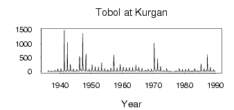
Name: | Tobol at Kurgan |
Field Definitions
Site Time Series Plot:
Site Data File:
(Units: m3/s)
| ID | Year | Jan | Feb | Mar | Apr | May | Jun | Jul | Aug | Sep | Oct | Nov | Dec |
|---|
| 7152 | 1936 | 1.36 | 1.49 | 1.54 | 6.44 | 30.50 | 6.16 | 4.68 | 2.90 | 1.17 | 1.10 | 2.86 | 1.15 |
| 7152 | 1937 | 0.95 | 1.09 | 1.45 | 7.58 | 27.40 | 7.64 | 1.28 | 1.34 | 1.17 | 3.03 | 3.13 | 2.28 |
| 7152 | 1938 | 2.14 | 1.51 | 1.56 | 24.80 | 49.20 | 19.80 | 13.30 | 7.62 | 5.95 | 4.80 | 4.00 | 3.00 |
| 7152 | 1939 | 2.03 | 2.15 | 2.63 | 100.00 | 60.60 | 7.77 | 3.15 | 3.55 | 3.42 | 5.50 | 7.77 | 7.38 |
| 7152 | 1940 | 4.32 | 2.82 | 2.83 | 109.00 | 79.00 | 17.90 | 3.33 | 2.53 | 4.87 | 4.72 | 6.77 | 5.98 |
| 7152 | 1941 | 2.63 | 2.52 | 3.86 | 19.70 | 1480.00 | 246.00 | 53.70 | 28.40 | 25.20 | 22.10 | 20.20 | 11.60 |
| 7152 | 1942 | 6.63 | 5.96 | 5.78 | 64.10 | 1040.00 | 145.00 | 40.00 | 22.10 | 17.90 | 17.40 | 14.20 | 12.30 |
| 7152 | 1943 | 10.30 | 7.42 | 5.20 | 259.00 | 238.00 | 48.00 | 26.70 | 23.20 | 27.10 | 22.50 | 16.60 | 10.80 |
| 7152 | 1944 | 9.09 | 8.00 | 6.87 | 95.70 | 76.20 | 28.20 | 19.00 | 13.30 | 11.50 | 10.80 | 11.30 | 4.66 |
| 7152 | 1945 | 3.69 | 2.61 | 3.09 | 15.50 | 80.20 | 49.80 | 31.00 | 33.50 | 26.80 | 21.50 | 16.50 | 9.85 |
| 7152 | 1946 | 8.32 | 7.26 | 6.57 | 537.00 | 434.00 | 89.30 | 40.40 | 60.50 | 87.00 | 61.70 | 47.90 | 25.10 |
| 7152 | 1947 | 15.60 | 13.10 | 11.40 | 1370.00 | 317.00 | 82.10 | 74.00 | 48.20 | 34.70 | 33.40 | 31.30 | 22.60 |
| 7152 | 1948 | 17.40 | 14.40 | 12.10 | 371.00 | 636.00 | 127.00 | 41.30 | 24.50 | 19.70 | 19.10 | 16.90 | 12.80 |
| 7152 | 1949 | 8.31 | 7.02 | 6.48 | 29.20 | 93.40 | 56.80 | 20.70 | 12.90 | 11.80 | 11.80 | 10.60 | 7.59 |
| 7152 | 1950 | 4.59 | 4.73 | 4.18 | 156.00 | 245.00 | 55.40 | 36.10 | 26.50 | 22.50 | 21.20 | 13.00 | 11.90 |
| 7152 | 1951 | 10.40 | 7.96 | 8.31 | 181.00 | 104.00 | 38.00 | 21.80 | 15.30 | 11.80 | 11.80 | 7.98 | 7.53 |
| 7152 | 1952 | 6.45 | 5.99 | 5.25 | 36.80 | 174.00 | 54.60 | 22.10 | 11.60 | 8.41 | 8.62 | 7.20 | 5.08 |
| 7152 | 1953 | 3.79 | 3.20 | 3.13 | 79.80 | 313.00 | 75.80 | 33.30 | 19.30 | 12.90 | 12.50 | 7.73 | 6.90 |
| 7152 | 1954 | 6.33 | 6.47 | 5.10 | 28.30 | 106.00 | 41.00 | 19.20 | 11.70 | 10.40 | 9.62 | 9.48 | 5.67 |
| 7152 | 1955 | 4.28 | 3.17 | 3.68 | 33.90 | 70.80 | 21.10 | 9.16 | 11.00 | 8.95 | 7.87 | 5.66 | 4.07 |
| 7152 | 1956 | 3.30 | 2.51 | 2.01 | 84.40 | 124.00 | 33.40 | 21.20 | 14.30 | 11.50 | 11.80 | 11.20 | 10.10 |
| 7152 | 1957 | 6.68 | 5.35 | 3.98 | 593.00 | 506.00 | 67.20 | 24.00 | 20.50 | 20.30 | 16.80 | 13.10 | 10.00 |
| 7152 | 1958 | 8.30 | 7.39 | 6.02 | 45.10 | 132.00 | 52.10 | 21.50 | 12.10 | 11.80 | 14.90 | 14.10 | 10.60 |
| 7152 | 1959 | 6.17 | 5.06 | 5.38 | 138.00 | 269.00 | 42.30 | 23.60 | 20.90 | 17.60 | 19.10 | 19.50 | 16.50 |
| 7152 | 1960 | 10.30 | 7.89 | 7.31 | 112.00 | 162.00 | 78.40 | 39.70 | 45.00 | 36.80 | 25.90 | 19.40 | 14.50 |
| 7152 | 1961 | 11.60 | 9.53 | 8.06 | 141.00 | 90.60 | 34.20 | 27.10 | 41.60 | 28.00 | 20.10 | 18.60 | 12.90 |
| 7152 | 1962 | 9.69 | 7.77 | 12.50 | 136.00 | 126.00 | 48.50 | 31.20 | 18.80 | 14.20 | 12.90 | 11.20 | 7.27 |
| 7152 | 1963 | 5.33 | 5.39 | 4.99 | 68.40 | 161.00 | 44.40 | 16.50 | 13.50 | 16.60 | 14.90 | 13.20 | 13.30 |
| 7152 | 1964 | 8.77 | 6.56 | 4.99 | 35.20 | 237.00 | 71.20 | 76.10 | 79.90 | 56.20 | 31.90 | 20.20 | 19.80 |
| 7152 | 1965 | 13.60 | 13.10 | 11.60 | 155.00 | 114.00 | 31.80 | 14.80 | 11.40 | 9.62 | 8.57 | 8.33 | 7.64 |
| 7152 | 1966 | 4.79 | 4.36 | 4.46 | 28.80 | 125.00 | 37.30 | 17.60 | 16.10 | 11.30 | 11.90 | 14.10 | 7.67 |
| 7152 | 1967 | 5.12 | 5.64 | 5.29 | 34.50 | 33.50 | 18.10 | 24.50 | 49.80 | 22.30 | 17.60 | 12.80 | 9.61 |
| 7152 | 1968 | 7.38 | 6.60 | 6.63 | 53.70 | 90.30 | 33.60 | 28.90 | 25.70 | 13.20 | 13.60 | 9.55 | 8.28 |
| 7152 | 1969 | 3.74 | 2.55 | 2.50 | 39.10 | 98.40 | 31.30 | 19.10 | 22.40 | 17.10 | 15.40 | 11.10 | 11.90 |
| 7152 | 1970 | 7.72 | 5.21 | 6.06 | 1020.00 | 358.00 | 88.70 | 56.40 | 24.50 | 23.10 | 22.50 | 12.70 | 7.72 |
| 7152 | 1971 | 7.89 | 8.13 | 10.20 | 159.00 | 469.00 | 81.70 | 34.80 | 30.50 | 27.30 | 24.90 | 24.20 | 18.40 |
| 7152 | 1972 | 12.90 | 9.91 | 9.61 | 154.00 | 185.00 | 35.60 | 22.00 | 17.90 | 13.20 | 13.60 | 12.10 | 11.60 |
| 7152 | 1973 | 12.40 | 6.84 | 5.29 | 34.80 | 39.60 | 16.20 | 17.20 | 14.60 | 12.10 | 13.10 | 12.30 | 7.87 |
| 7152 | 1974 | 5.56 | 4.48 | 5.01 | 113.00 | 61.80 | 16.70 | 12.90 | 11.00 | 8.41 | 8.08 | 8.34 | 5.76 |
| 7152 | 1975 | 2.53 | 2.37 | 2.53 | 19.00 | 9.62 | 1.41 | 0.99 | 0.57 | 0.58 | 0.87 | 1.65 | 1.73 |
| 7152 | 1976 | 1.59 | 1.11 | 0.89 | | | 1.09 | 0.48 | 0.51 | 0.75 | 0.37 | 0.38 | 0.26 |
| 7152 | 1977 | 0.29 | 0.14 | 0.35 | 30.80 | 18.50 | 3.14 | 1.48 | 1.15 | 0.82 | 1.33 | 1.87 | 3.06 |
| 7152 | 1978 | 1.20 | 0.85 | 1.73 | 106.00 | 76.50 | 12.40 | 6.49 | 6.52 | 6.50 | 3.94 | 3.70 | 2.80 |
| 7152 | 1979 | 1.53 | 1.50 | 2.05 | 23.20 | 83.90 | 22.90 | 8.74 | 3.76 | 2.92 | 1.75 | 2.36 | 2.88 |
| 7152 | 1980 | 3.18 | 2.00 | 2.37 | 47.60 | 78.20 | 16.10 | 5.33 | 2.97 | 3.28 | 4.40 | 10.60 | 6.06 |
| 7152 | 1981 | 4.62 | 3.44 | 3.41 | 48.40 | 103.00 | 34.80 | 14.80 | 7.04 | 3.47 | 8.16 | 9.27 | 4.60 |
| 7152 | 1982 | 2.89 | 2.68 | 3.13 | 16.00 | 39.90 | 10.90 | 7.79 | 4.76 | 4.93 | 9.87 | 8.26 | 5.70 |
| 7152 | 1983 | 4.87 | 4.51 | 4.36 | 108.00 | 103.00 | 21.30 | 7.31 | 6.65 | 11.50 | 15.80 | 10.30 | 8.88 |
| 7152 | 1984 | 6.55 | 4.59 | 4.49 | 31.80 | 25.80 | 6.16 | 3.35 | 1.88 | 4.77 | 10.10 | 7.02 | 4.75 |
| 7152 | 1985 | 3.25 | 2.48 | 1.48 | 161.00 | 274.00 | 47.70 | 23.80 | 25.00 | 26.50 | 16.20 | 13.20 | 7.44 |
| 7152 | 1986 | 4.70 | 3.03 | 5.92 | 71.60 | 107.00 | 25.00 | 15.30 | 16.90 | 12.30 | 10.90 | 9.65 | 7.36 |
| 7152 | 1987 | 4.93 | 5.55 | 5.17 | 123.00 | 613.00 | 107.00 | 22.80 | 21.00 | 21.90 | 28.00 | 22.90 | 17.80 |
| 7152 | 1988 | 11.90 | 8.43 | 8.12 | 95.00 | 152.00 | 29.50 | 15.70 | 12.30 | 11.70 | 9.92 | 7.86 | 6.68 |
| 7152 | 1989 | 4.45 | 3.54 | 4.61 | 31.80 | 76.20 | 40.20 | 11.10 | 6.33 | 5.70 | 5.95 | 6.99 | 6.13 |
 Return to R-Arctic Net Home Page