Tobol at Novoil'inovka
Ob
| PointID: | 7148 |
Code: | 12005 |
Latitude (decimal degrees): | 52.63 |
Longitude (decimal degrees): | 62.70 |
Drainage Area (km2): | 16100.00 |
Source: | SHI |
Hydrological Zone: | Ob |
Name: | Tobol at Novoil'inovka |
Field Definitions
Site Time Series Plot:
Site Data File:
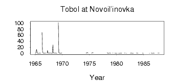
(Units: m3/s)
| ID | Year | Jan | Feb | Mar | Apr | May | Jun | Jul | Aug | Sep | Oct | Nov | Dec |
|---|
| 7148 | 1965 | 0.23 | 0.32 | 5.76 | 13.10 | 2.77 | 0.36 | 0.21 | 0.22 | 0.10 | 0.41 | 0.39 | 0.41 |
| 7148 | 1966 | 0.06 | | | 68.60 | 7.22 | 1.18 | 1.02 | 0.30 | 0.17 | 0.57 | 0.92 | 0.21 |
| 7148 | 1967 | | | 0.02 | 9.48 | 1.76 | 1.02 | 1.25 | 0.82 | 0.46 | 0.54 | 0.60 | 0.39 |
| 7148 | 1968 | 0.25 | 0.05 | 0.18 | 27.50 | 2.61 | 0.92 | 0.43 | 0.33 | 0.68 | 0.78 | 0.40 | 0.18 |
| 7148 | 1969 | 0.01 | | | 101.00 | 2.52 | 1.12 | 0.35 | 0.18 | 0.07 | 0.43 | 0.92 | 0.56 |
| 7148 | 1974 | | | | | 0.33 | 1.13 | 1.91 | 2.44 | 1.31 | 1.51 | | |
| 7148 | 1975 | | | | | 0.63 | 0.51 | 1.59 | 2.16 | 1.68 | | | |
| 7148 | 1978 | | | | 2.26 | 0.26 | 0.12 | 0.29 | 0.44 | 0.47 | 0.53 | 0.61 | 0.12 |
| 7148 | 1979 | | | | 0.61 | 0.45 | | | | 0.33 | 0.26 | 0.29 | 0.18 |
| 7148 | 1980 | 0.03 | 0.06 | | | 0.32 | 0.21 | 0.22 | 0.27 | 0.27 | 0.49 | 0.36 | 0.20 |
| 7148 | 1981 | | | | | | 0.46 | 0.39 | 0.34 | | 0.24 | 0.21 | |
| 7148 | 1982 | | | | | | | 0.30 | 0.56 | 0.52 | 0.43 | 0.17 | 0.22 |
| 7148 | 1983 | 0.21 | 0.24 | | | | 0.62 | | 0.50 | 0.62 | 0.61 | 0.46 | 0.23 |
| 7148 | 1984 | | | | | 0.30 | | | | | 0.41 | 0.23 | 0.03 |
| 7148 | 1985 | | | | | | 0.56 | | | 0.28 | | | |
| 7148 | 1986 | 0.00 | 0.00 | | | 0.58 | 0.46 | 0.31 | 0.29 | 0.31 | 0.51 | 0.43 | 0.27 |
| 7148 | 1987 | | | | | | | | 0.34 | 0.57 | 0.57 | 0.44 | |
 Return to R-Arctic Net Home Page