Irtish at Pavlodar
Ob
| PointID: | 7140 |
Code: | 11667 |
Latitude (decimal degrees): | 52.25 |
Longitude (decimal degrees): | 76.93 |
Drainage Area (km2): | 240000.00 |
Source: | SHI |
Hydrological Zone: | Ob |
Name: | Irtish at Pavlodar |
Field Definitions
Site Time Series Plot:
Site Data File:
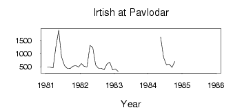
(Units: m3/s)
| ID | Year | Jan | Feb | Mar | Apr | May | Jun | Jul | Aug | Sep | Oct | Nov | Dec |
|---|
| 7140 | 1981 | 489.00 | 487.00 | 462.00 | 1250.00 | 1870.00 | 877.00 | 546.00 | 444.00 | 440.00 | 526.00 | 546.00 | 493.00 |
| 7140 | 1982 | 620.00 | 516.00 | 497.00 | 1300.00 | 1220.00 | 574.00 | 452.00 | 448.00 | 387.00 | 596.00 | 679.00 | 389.00 |
| 7140 | 1983 | 421.00 | 325.00 | | | | | | | | | | |
| 7140 | 1984 | 526.00 | | | | 1610.00 | 850.00 | 580.00 | 604.00 | 480.00 | 700.00 | | |
| 7140 | 1985 | | 589.00 | | | | 1170.00 | | | | | | 704.00 |
| Other Close Sites |
|---|
| PointID |
Latitude |
Longitude | Drainage Area | Source |
Name |
|---|
| 6948 | 52.25 | 76.93 | 240000.00 | SHI | Irtish at Pavlodar |
 Return to R-Arctic Net Home Page