Irtish at Bobrovsky
Ob
| PointID: | 7136 |
Code: | 11663 |
Latitude (decimal degrees): | 53.22 |
Longitude (decimal degrees): | 75.68 |
Drainage Area (km2): | 244000.00 |
Source: | SHI |
Hydrological Zone: | Ob |
Name: | Irtish at Bobrovsky |
Field Definitions
Site Time Series Plot:
Site Data File:
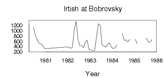
(Units: m3/s)
| ID | Year | Jan | Feb | Mar | Apr | May | Jun | Jul | Aug | Sep | Oct | Nov | Dec |
|---|
| 7136 | 1980 | | | | | | 1120.00 | 798.00 | 642.00 | 509.00 | 508.00 | 420.00 | 317.00 |
| 7136 | 1982 | 385.00 | 329.00 | 374.00 | 1050.00 | 1350.00 | 675.00 | 432.00 | 430.00 | 356.00 | 580.00 | 633.00 | 281.00 |
| 7136 | 1983 | 277.00 | 238.00 | 241.00 | 734.00 | 1260.00 | 1210.00 | 476.00 | 419.00 | 375.00 | 469.00 | 542.00 | 387.00 |
| 7136 | 1984 | 324.00 | 341.00 | 454.00 | | | 888.00 | 639.00 | 646.00 | 573.00 | 669.00 | | |
| 7136 | 1985 | 676.00 | 511.00 | | | | | 722.00 | 577.00 | 563.00 | 662.00 | | |
 Return to R-Arctic Net Home Page