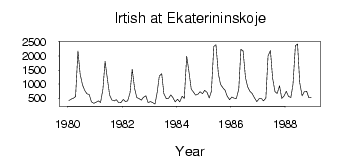
| PointID: | 7134 | Code: | 11619 | Latitude (decimal degrees): | 56.92 | Longitude (decimal degrees): | 74.53 | Drainage Area (km2): | 376000.00 | Source: | SHI | Hydrological Zone: | Ob | Name: | Irtish at Ekaterininskoje |
|---|
| Download | |
|---|---|
| Site Descriptor Information | Site Time Series Data |
| Link to all available data | |
| ID | Year | Jan | Feb | Mar | Apr | May | Jun | Jul | Aug | Sep | Oct | Nov | Dec |
|---|---|---|---|---|---|---|---|---|---|---|---|---|---|
| 7134 | 1980 | 410.00 | 458.00 | 492.00 | 554.00 | 2180.00 | 1360.00 | 967.00 | 777.00 | 656.00 | 621.00 | 370.00 | 315.00 |
| 7134 | 1981 | 351.00 | 398.00 | 346.00 | 824.00 | 1810.00 | 1220.00 | 609.00 | 440.00 | 403.00 | 447.00 | 330.00 | 340.00 |
| 7134 | 1982 | 453.00 | 376.00 | 400.00 | 689.00 | 1530.00 | 844.00 | 523.00 | 478.00 | 424.00 | 526.00 | 585.00 | 346.00 |
| 7134 | 1983 | 374.00 | 342.00 | 288.00 | 705.00 | 1290.00 | 1370.00 | 658.00 | 475.00 | 484.00 | 618.00 | 509.00 | 371.00 |
| 7134 | 1984 | 460.00 | 371.00 | 568.00 | 484.00 | 1990.00 | 1470.00 | 820.00 | 717.00 | 609.00 | 641.00 | 729.00 | 659.00 |
| 7134 | 1985 | 776.00 | 698.00 | 505.00 | 742.00 | 2340.00 | 2400.00 | 1370.00 | 988.00 | 861.00 | 774.00 | 566.00 | 443.00 |
| 7134 | 1986 | 536.00 | 499.00 | 489.00 | 818.00 | 2240.00 | 2180.00 | 1230.00 | 904.00 | 738.00 | 662.00 | 502.00 | 379.00 |
| 7134 | 1987 | 480.00 | 486.00 | 400.00 | 503.00 | 2000.00 | 2200.00 | 1210.00 | 728.00 | 665.00 | 941.00 | 483.00 | 568.00 |
| 7134 | 1988 | 743.00 | 564.00 | 520.00 | 992.00 | 2370.00 | 2430.00 | 1050.00 | 578.00 | 725.00 | 740.00 | 514.00 | 521.00 |
 Return to R-Arctic Net Home Page