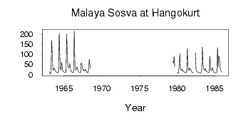
| PointID: | 7130 | Code: | 11613 | Latitude (decimal degrees): | 62.07 | Longitude (decimal degrees): | 64.30 | Drainage Area (km2): | 4540.00 | Source: | SHI | Hydrological Zone: | Ob | Name: | Malaya Sosva at Hangokurt |
|---|
| Download | |
|---|---|
| Site Descriptor Information | Site Time Series Data |
| Link to all available data | |
| ID | Year | Jan | Feb | Mar | Apr | May | Jun | Jul | Aug | Sep | Oct | Nov | Dec |
|---|---|---|---|---|---|---|---|---|---|---|---|---|---|
| 7130 | 1963 | 12.60 | 10.80 | 1.06 | 14.00 | 170.00 | 109.00 | 22.50 | 20.00 | 30.80 | 25.80 | 16.50 | 13.30 |
| 7130 | 1964 | 10.80 | 9.36 | 8.15 | 8.93 | 206.00 | 111.00 | 29.50 | 20.60 | 59.70 | 35.30 | 15.00 | 12.10 |
| 7130 | 1965 | 11.20 | 9.91 | 9.44 | 12.20 | 199.00 | 109.00 | 35.50 | 34.20 | 32.40 | 55.00 | 27.70 | 13.00 |
| 7130 | 1966 | 12.20 | 10.30 | 8.90 | 10.80 | 213.00 | 61.30 | 21.60 | 20.40 | 37.40 | 36.40 | 17.70 | 11.00 |
| 7130 | 1967 | 7.69 | 8.42 | 8.75 | 55.40 | 54.50 | 33.20 | 20.00 | 23.20 | 17.40 | 17.10 | 25.40 | 17.60 |
| 7130 | 1968 | 10.00 | 9.18 | 9.66 | 24.20 | 76.10 | 45.70 | 30.00 | |||||
| 7130 | 1979 | 63.40 | 55.00 | 90.40 | 36.60 | ||||||||
| 7130 | 1980 | 7.85 | 6.15 | 5.37 | 37.40 | 103.00 | 40.90 | 20.00 | 18.70 | 25.70 | 15.80 | 14.80 | 11.90 |
| 7130 | 1981 | 9.37 | 8.46 | 8.47 | 9.41 | 129.00 | 39.40 | 18.90 | 20.70 | 32.90 | 24.30 | 20.60 | 12.90 |
| 7130 | 1982 | 8.94 | 7.76 | 7.69 | 107.00 | 22.70 | 14.20 | 14.00 | 10.20 | 9.71 | 8.24 | ||
| 7130 | 1983 | 7.18 | 7.16 | 7.60 | 26.30 | 135.00 | 55.50 | 26.40 | 19.20 | 19.00 | 30.00 | 15.20 | 13.60 |
| 7130 | 1984 | 12.50 | 10.80 | 9.76 | 10.60 | 90.20 | 26.00 | 18.80 | 17.60 | 33.70 | 25.10 | 10.60 | 8.86 |
| 7130 | 1985 | 7.89 | 7.06 | 7.33 | 11.10 | 133.00 | 34.20 | 88.20 | 88.40 | 32.50 | 27.30 | 14.40 | 11.60 |
 Return to R-Arctic Net Home Page