Harampur at Harampur
Ob
| PointID: | 7128 |
Code: | 11611 |
Latitude (decimal degrees): | 64.28 |
Longitude (decimal degrees): | 78.10 |
Drainage Area (km2): | 4330.00 |
Source: | SHI |
Hydrological Zone: | Ob |
Name: | Harampur at Harampur |
Field Definitions
Site Time Series Plot:
Site Data File:
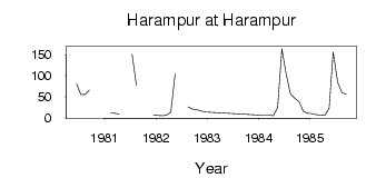
(Units: m3/s)
| ID | Year | Jan | Feb | Mar | Apr | May | Jun | Jul | Aug | Sep | Oct | Nov | Dec |
|---|
| 7128 | 1980 | | | | | | 80.60 | 55.00 | 55.70 | 65.70 | | | |
| 7128 | 1981 | | 12.30 | 10.80 | 8.52 | | | 151.00 | 77.00 | | | | 6.54 |
| 7128 | 1982 | 5.84 | 4.80 | 6.01 | 13.10 | 104.00 | | | 26.10 | 20.80 | 19.80 | 16.50 | 13.80 |
| 7128 | 1984 | 6.47 | 6.31 | 6.11 | 5.16 | 24.30 | 164.00 | 104.00 | 56.90 | 46.30 | 38.40 | 15.70 | 11.00 |
| 7128 | 1985 | 9.85 | 7.80 | 6.31 | 5.67 | 22.60 | 156.00 | 84.10 | 59.90 | 56.70 | | | |
 Return to R-Arctic Net Home Page