Demyanka at Sorovaya
Ob
| PointID: | 7124 |
Code: | 11588 |
Latitude (decimal degrees): | 59.52 |
Longitude (decimal degrees): | 69.92 |
Drainage Area (km2): | 32700.00 |
Source: | SHI |
Hydrological Zone: | Ob |
Name: | Demyanka at Sorovaya |
Field Definitions
Site Time Series Plot:
Site Data File:
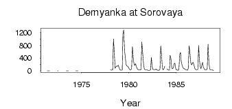
(Units: m3/s)
| ID | Year | Jan | Feb | Mar | Apr | May | Jun | Jul | Aug | Sep | Oct | Nov | Dec |
|---|
| 7124 | 1971 | | | | | 0.34 | 0.26 | 0.22 | 0.12 | | | | |
| 7124 | 1972 | | | | | | 0.36 | 0.36 | | | | | |
| 7124 | 1973 | | | | | 0.77 | 0.62 | 0.48 | 0.31 | | | | |
| 7124 | 1974 | | | | | 0.32 | 0.31 | 0.18 | 0.14 | | | | |
| 7124 | 1978 | 27.90 | 25.60 | 22.10 | 37.60 | 998.00 | 562.00 | 81.50 | 120.00 | 154.00 | 146.00 | 174.00 | 112.00 |
| 7124 | 1979 | 46.00 | 21.50 | 20.40 | 21.20 | 1150.00 | 1280.00 | 639.00 | 424.00 | 209.00 | 148.00 | 150.00 | 110.00 |
| 7124 | 1980 | 64.10 | 30.90 | 26.10 | 73.10 | 757.00 | 398.00 | 235.00 | 168.00 | 226.00 | 136.00 | 75.80 | 44.90 |
| 7124 | 1981 | 36.00 | 29.20 | 30.50 | 44.00 | 899.00 | 578.00 | 239.00 | 63.80 | 30.80 | 30.60 | 25.50 | 25.20 |
| 7124 | 1982 | 16.90 | 14.80 | 14.70 | 39.10 | 428.00 | 154.00 | 47.60 | 40.60 | 37.90 | 44.70 | 59.10 | 32.90 |
| 7124 | 1983 | 22.60 | 18.80 | 20.30 | 46.50 | 780.00 | 481.00 | 78.30 | 33.80 | 64.90 | 147.00 | | |
| 7124 | 1984 | 64.20 | 37.30 | 23.90 | 23.70 | 486.00 | 372.00 | 84.70 | 69.00 | 106.00 | 219.00 | 240.00 | 68.00 |
| 7124 | 1985 | 29.80 | 25.60 | 19.30 | 48.60 | 509.00 | 577.00 | 301.00 | 188.00 | 109.00 | 75.30 | 67.40 | 49.90 |
| 7124 | 1986 | 33.30 | 26.90 | 24.50 | 75.80 | 789.00 | 561.00 | 266.00 | 188.00 | 222.00 | 270.00 | 189.00 | 96.00 |
| 7124 | 1987 | 44.80 | 36.70 | 30.70 | 52.80 | 791.00 | 405.00 | 146.00 | 66.10 | 183.00 | 265.00 | 117.00 | 70.80 |
| 7124 | 1988 | 29.80 | 29.20 | 28.70 | 69.40 | 832.00 | 273.00 | 67.20 | 33.40 | 32.40 | 30.70 | 22.30 | 19.50 |
 Return to R-Arctic Net Home Page