Polui at Gluharinoje
Ob
| PointID: | 7117 |
Code: | 11573 |
Latitude (decimal degrees): | 65.58 |
Longitude (decimal degrees): | 69.03 |
Drainage Area (km2): | 10700.00 |
Source: | SHI |
Hydrological Zone: | Ob |
Name: | Polui at Gluharinoje |
Field Definitions
Site Time Series Plot:
Site Data File:
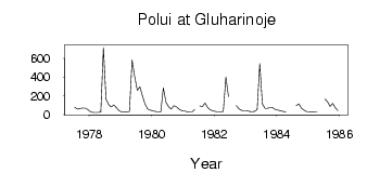
(Units: m3/s)
| ID | Year | Jan | Feb | Mar | Apr | May | Jun | Jul | Aug | Sep | Oct | Nov | Dec |
|---|
| 7117 | 1977 | | | | | | | 77.70 | 57.50 | 61.50 | 67.90 | 68.20 | 50.90 |
| 7117 | 1978 | 29.30 | 21.90 | 20.60 | 20.10 | 27.30 | 717.00 | 162.00 | 105.00 | 79.10 | 101.00 | 70.20 | 41.60 |
| 7117 | 1979 | 26.60 | 23.80 | 27.80 | 31.10 | 582.00 | 406.00 | 258.00 | 297.00 | 195.00 | 110.00 | 57.50 | 45.10 |
| 7117 | 1980 | 38.10 | 31.20 | 27.70 | 26.80 | 285.00 | 131.00 | 81.80 | 56.50 | 93.70 | 82.90 | 56.00 | 40.50 |
| 7117 | 1981 | 36.60 | 30.00 | 27.10 | 26.00 | 52.10 | | 91.80 | 84.90 | 122.00 | 73.50 | 49.50 | 37.70 |
| 7117 | 1982 | 30.90 | 27.70 | 26.60 | 33.30 | 400.00 | 190.00 | | | 93.40 | 60.20 | 44.00 | 41.70 |
| 7117 | 1983 | 39.50 | 33.30 | 29.20 | 30.90 | 51.00 | 544.00 | 112.00 | 64.40 | 66.60 | 73.50 | 70.50 | 52.00 |
| 7117 | 1984 | 47.10 | 36.80 | 32.70 | 27.70 | | | | 92.10 | 113.00 | 65.20 | 46.90 | 30.00 |
| 7117 | 1985 | 28.90 | 27.90 | 24.50 | 24.10 | | | 165.00 | 134.00 | 83.90 | 119.00 | 72.40 | 39.60 |
 Return to R-Arctic Net Home Page