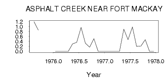
| PointID: | 711 | Code: | 07DA012 | Latitude (decimal degrees): | 57.53 | Longitude (decimal degrees): | -111.67 | Drainage Area (km2): | 148.00 | Source: | Hydat | Hydrological Zone: | Mackenzie | Name: | ASPHALT CREEK NEAR FORT MACKAY |
|---|
| Download | |
|---|---|
| Site Descriptor Information | Site Time Series Data |
| Link to all available data | |
| ID | Year | Jan | Feb | Mar | Apr | May | Jun | Jul | Aug | Sep | Oct | Nov | Dec |
|---|---|---|---|---|---|---|---|---|---|---|---|---|---|
| 711 | 1975 | 1.19 | 0.85 | ||||||||||
| 711 | 1976 | 0.00 | 0.00 | 0.00 | 0.00 | 0.30 | 0.36 | 0.96 | 0.33 | 0.17 | 0.51 | 0.00 | 0.00 |
| 711 | 1977 | 0.00 | 0.00 | 0.00 | 0.00 | 0.89 | 0.47 | 0.98 | 0.20 | 0.21 | 0.47 | 0.00 | 0.00 |
 Return to R-Arctic Net Home Page