Hulga at yansunt
Ob
| PointID: | 7107 |
Code: | 11549 |
Latitude (decimal degrees): | 64.35 |
Longitude (decimal degrees): | 61.12 |
Drainage Area (km2): | 9010.00 |
Source: | SHI |
Hydrological Zone: | Ob |
Name: | Hulga at yansunt |
Field Definitions
Site Time Series Plot:
Site Data File:
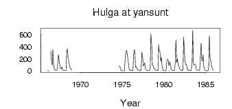
(Units: m3/s)
| ID | Year | Jan | Feb | Mar | Apr | May | Jun | Jul | Aug | Sep | Oct | Nov | Dec |
|---|
| 7107 | 1966 | 4.96 | 2.91 | 1.61 | 2.00 | | 337.00 | 180.00 | 96.70 | 356.00 | 126.00 | 34.80 | 21.20 |
| 7107 | 1967 | 10.90 | 8.83 | 9.10 | 88.00 | 272.00 | 170.00 | 107.00 | 37.20 | 40.90 | 66.20 | 16.90 | 7.30 |
| 7107 | 1968 | 7.11 | 7.94 | 8.21 | 8.33 | 331.00 | 367.00 | 199.00 | 151.00 | 88.10 | 49.10 | 35.70 | 12.60 |
| 7107 | 1974 | | | | | | | | 71.80 | 84.00 | 52.50 | 17.20 | 7.68 |
| 7107 | 1975 | 5.01 | 3.38 | 2.76 | 5.02 | 217.00 | 296.00 | 343.00 | 264.00 | 187.00 | 98.00 | 19.30 | 14.50 |
| 7107 | 1976 | 5.53 | 5.37 | 6.02 | 7.94 | 260.00 | 352.00 | 319.00 | 59.70 | 73.20 | 33.40 | 20.50 | 13.10 |
| 7107 | 1977 | 6.84 | 2.87 | 3.20 | 22.00 | 310.00 | 231.00 | 82.70 | 99.70 | 135.00 | 34.20 | 26.80 | 12.50 |
| 7107 | 1978 | 6.87 | 5.66 | 4.99 | 4.79 | 45.50 | 612.00 | 430.00 | 93.00 | 92.10 | 50.20 | 33.40 | 19.10 |
| 7107 | 1979 | 8.89 | 5.51 | 6.02 | 7.47 | 435.00 | 327.00 | 317.00 | 160.00 | 227.00 | 82.20 | 24.30 | 10.10 |
| 7107 | 1980 | 4.09 | 2.70 | 1.90 | 24.00 | 183.00 | 195.00 | 170.00 | 83.40 | 152.00 | 114.00 | 27.20 | 14.90 |
| 7107 | 1981 | 10.50 | 7.12 | 5.18 | 4.83 | 141.00 | 513.00 | 135.00 | 203.00 | 123.00 | 81.10 | 46.20 | 18.10 |
| 7107 | 1982 | 9.92 | 6.85 | 4.21 | 23.50 | 561.00 | 348.00 | 171.00 | 106.00 | 110.00 | 33.80 | 19.90 | 12.20 |
| 7107 | 1983 | 8.80 | 7.33 | 5.47 | 6.39 | 132.00 | 679.00 | 138.00 | 96.00 | 109.00 | 103.00 | 34.00 | 15.90 |
| 7107 | 1984 | 11.50 | 10.30 | 8.10 | 6.65 | 213.00 | 462.00 | 184.00 | 163.00 | 266.00 | 74.50 | 27.50 | 11.90 |
| 7107 | 1985 | 6.11 | 3.01 | 2.55 | 3.92 | 68.70 | 586.00 | 229.00 | 161.00 | 84.10 | 55.00 | 26.30 | 10.60 |
 Return to R-Arctic Net Home Page