| PointID: | 710 | Code: | 07DA011 | Latitude (decimal degrees): | 57.66 | Longitude (decimal degrees): | -111.51 | Drainage Area (km2): | 274.00 | Source: | Hydat | Hydrological Zone: | Mackenzie | Name: | UNNAMED CREEK NEAR FORT MACKAY |
|---|
| Download | |
|---|---|
| Site Descriptor Information | Site Time Series Data |
| Link to all available data | |
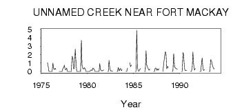
| ID | Year | Jan | Feb | Mar | Apr | May | Jun | Jul | Aug | Sep | Oct | Nov | Dec |
|---|---|---|---|---|---|---|---|---|---|---|---|---|---|
| 710 | 1975 | 1.07 | 0.54 | 0.00 | 0.00 | ||||||||
| 710 | 1976 | 0.00 | 0.00 | 0.00 | 1.00 | 0.36 | 0.24 | 0.39 | 0.25 | 0.00 | |||
| 710 | 1977 | 0.00 | 0.00 | 0.00 | 0.00 | 0.36 | 0.48 | 0.74 | 0.26 | 0.22 | 0.42 | 0.00 | 0.00 |
| 710 | 1978 | 0.00 | 0.00 | 0.00 | 0.00 | 1.80 | 1.60 | 0.32 | 0.38 | 2.65 | 1.30 | 0.00 | 0.00 |
| 710 | 1979 | 0.00 | 0.00 | 0.00 | 0.00 | 3.70 | 0.81 | 0.33 | 0.31 | 0.45 | 0.32 | 0.00 | 0.00 |
| 710 | 1980 | 0.00 | 0.00 | 0.00 | 0.00 | 0.17 | 0.19 | 0.13 | 0.41 | 0.33 | 0.21 | 0.00 | 0.00 |
| 710 | 1981 | 0.00 | 0.00 | 0.00 | 0.00 | 0.95 | 0.21 | 0.13 | 0.06 | 0.14 | 0.18 | ||
| 710 | 1982 | 0.00 | 0.00 | 1.31 | 0.37 | 0.06 | 0.09 | 0.07 | 0.06 | ||||
| 710 | 1983 | 0.00 | 0.00 | 0.47 | 0.07 | 0.26 | 0.37 | 0.10 | 0.20 | ||||
| 710 | 1984 | 0.00 | 0.00 | 0.42 | 1.04 | 0.57 | 0.77 | ||||||
| 710 | 1985 | 0.00 | 0.00 | 4.90 | 0.47 | 0.07 | 0.07 | 0.26 | 0.35 | ||||
| 710 | 1986 | 0.00 | 0.00 | 2.45 | 0.76 | 0.52 | 0.32 | 0.17 | 0.29 | ||||
| 710 | 1987 | 0.00 | 0.00 | 0.40 | 0.42 | 0.15 | 0.31 | 0.17 | 0.36 | ||||
| 710 | 1988 | 0.00 | 1.00 | 1.67 | 2.34 | 2.25 | 0.33 | 0.63 | 0.41 | ||||
| 710 | 1989 | 0.00 | 0.00 | 2.11 | 0.62 | 0.46 | 0.36 | 0.29 | 0.29 | ||||
| 710 | 1990 | 0.00 | 0.00 | 2.26 | 1.98 | 0.38 | 0.11 | 0.14 | 0.15 | ||||
| 710 | 1991 | 0.00 | 0.00 | 0.51 | 2.31 | 0.72 | 0.17 | 0.37 | |||||
| 710 | 1992 | 0.00 | 0.00 | 0.72 | 1.61 | 0.36 | 0.13 | 0.24 | |||||
| 710 | 1993 | 0.00 | 0.00 | 1.41 | 1.31 | 0.83 | 0.56 | 0.32 | 0.33 |
 Return to R-Arctic Net Home Page