| PointID: | 7099 | Code: | 11537 | Latitude (decimal degrees): | 62.17 | Longitude (decimal degrees): | 60.32 | Drainage Area (km2): | 2210.00 | Source: | SHI | Hydrological Zone: | Ob | Name: | Severnaya Sosva at Ust-Manya |
|---|
| Download | |
|---|---|
| Site Descriptor Information | Site Time Series Data |
| Link to all available data | |
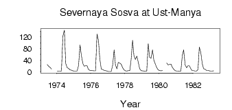
| ID | Year | Jan | Feb | Mar | Apr | May | Jun | Jul | Aug | Sep | Oct | Nov | Dec |
|---|---|---|---|---|---|---|---|---|---|---|---|---|---|
| 7099 | 1973 | 24.80 | 18.80 | 15.30 | 9.58 | ||||||||
| 7099 | 1974 | 2.54 | 2.43 | 2.38 | 2.95 | 123.00 | 143.00 | 28.90 | 13.90 | 11.90 | 6.91 | 5.67 | 3.46 |
| 7099 | 1975 | 2.74 | 2.48 | 2.78 | 21.50 | 92.20 | 56.70 | 28.70 | 19.40 | 21.00 | 20.30 | 7.80 | 4.76 |
| 7099 | 1976 | 4.24 | 4.06 | 3.46 | 3.52 | 130.00 | 107.00 | 44.80 | 8.90 | 7.58 | 4.95 | 4.12 | 2.54 |
| 7099 | 1977 | 1.06 | 0.86 | 1.04 | 22.70 | 75.60 | 23.10 | 10.00 | 32.30 | 29.90 | 26.10 | 14.90 | 6.87 |
| 7099 | 1978 | 3.57 | 2.91 | 3.74 | 4.20 | 41.50 | 108.00 | 56.90 | 42.50 | 53.50 | 33.70 | 10.50 | 4.14 |
| 7099 | 1979 | 3.37 | 2.59 | 1.99 | 2.59 | 96.80 | 50.60 | 46.20 | 75.50 | 39.90 | 26.40 | 15.20 | 6.73 |
| 7099 | 1980 | 4.34 | 3.39 | 4.71 | 30.20 | 23.90 | 25.40 | 26.40 | 15.60 | 8.38 | 3.90 | ||
| 7099 | 1981 | 2.99 | 2.51 | 2.42 | 2.51 | 57.10 | 75.20 | 23.80 | 14.30 | 20.60 | 20.30 | 9.77 | 3.61 |
| 7099 | 1982 | 3.95 | 2.80 | 2.79 | 8.09 | 85.00 | 66.30 | 27.50 | 10.50 | 9.13 | 4.75 | 4.90 | 3.39 |
| 7099 | 1983 | 2.92 | 2.59 | 3.53 |
 Return to R-Arctic Net Home Page