Kuma at Kuminsky
Ob
| PointID: | 7095 |
Code: | 11529 |
Latitude (decimal degrees): | 58.82 |
Longitude (decimal degrees): | 66.00 |
Drainage Area (km2): | 1670.00 |
Source: | SHI |
Hydrological Zone: | Ob |
Name: | Kuma at Kuminsky |
Field Definitions
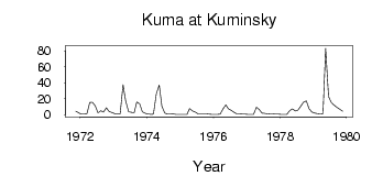
Site Time Series Plot:
Site Data File:
(Units: m3/s)
| ID | Year | Jan | Feb | Mar | Apr | May | Jun | Jul | Aug | Sep | Oct | Nov | Dec |
|---|
| 7095 | 1971 | | | | | | | | | | | 4.31 | 2.09 |
| 7095 | 1972 | 0.70 | 0.60 | 0.78 | 15.10 | 15.40 | 10.90 | 2.29 | 4.76 | 3.25 | 8.56 | 3.83 | 2.51 |
| 7095 | 1973 | 1.31 | 0.73 | 0.77 | 37.20 | 17.30 | 3.49 | 2.88 | 2.16 | 15.90 | 13.60 | 3.42 | 1.44 |
| 7095 | 1974 | 0.79 | 0.42 | 0.45 | 26.00 | 36.90 | 10.50 | 1.91 | 0.75 | 0.62 | 0.82 | 0.41 | 0.26 |
| 7095 | 1975 | 0.17 | 0.16 | 0.32 | 7.41 | 4.47 | 3.34 | 1.01 | 0.80 | 0.77 | 1.05 | 0.60 | 0.30 |
| 7095 | 1976 | 0.31 | 0.34 | 0.44 | 6.96 | 12.10 | 7.37 | 5.23 | 2.83 | 1.06 | 0.91 | 0.71 | 0.63 |
| 7095 | 1977 | 0.38 | 0.27 | 0.28 | 9.34 | 6.55 | 1.81 | 1.47 | 0.96 | 1.15 | 1.26 | 0.71 | 0.45 |
| 7095 | 1978 | 0.31 | 0.27 | 0.29 | 4.85 | 7.30 | 4.53 | 5.51 | 10.50 | 15.60 | 17.20 | 7.58 | 3.12 |
| 7095 | 1979 | 1.86 | 1.25 | 0.95 | 1.25 | 83.10 | 22.70 | 14.70 | 12.00 | 9.25 | 6.72 | 4.25 | |
 Return to R-Arctic Net Home Page