Konda at Chantir'ya
Ob
| PointID: | 7090 |
Code: | 11520 |
Latitude (decimal degrees): | 60.32 |
Longitude (decimal degrees): | 64.22 |
Drainage Area (km2): | 13900.00 |
Source: | SHI |
Hydrological Zone: | Ob |
Name: | Konda at Chantir'ya |
Field Definitions
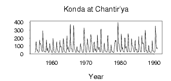
Site Time Series Plot:
Site Data File:
(Units: m3/s)
| ID | Year | Jan | Feb | Mar | Apr | May | Jun | Jul | Aug | Sep | Oct | Nov | Dec |
|---|
| 7090 | 1955 | 21.50 | 22.30 | 23.50 | 39.10 | 148.00 | 154.00 | 109.00 | 65.10 | 42.40 | 50.20 | 50.30 | 25.50 |
| 7090 | 1956 | 20.70 | 19.80 | 21.50 | 29.40 | 129.00 | 176.00 | 124.00 | 129.00 | 130.00 | 131.00 | 85.90 | 59.00 |
| 7090 | 1957 | 51.40 | 39.00 | 27.80 | 35.90 | 293.00 | 176.00 | 120.00 | 61.10 | 31.70 | 35.80 | 32.60 | 25.90 |
| 7090 | 1958 | 25.10 | 23.70 | 21.50 | 35.00 | 130.00 | 177.00 | 95.50 | 39.00 | 44.90 | 76.80 | 55.80 | 37.40 |
| 7090 | 1959 | 17.20 | 19.30 | 22.50 | 42.80 | 132.00 | 122.00 | 79.90 | 65.50 | 49.60 | 46.50 | 36.50 | 21.00 |
| 7090 | 1960 | 20.50 | 20.30 | 18.50 | 55.20 | 196.00 | 153.00 | 91.10 | 37.80 | 33.70 | 27.00 | 18.60 | 19.20 |
| 7090 | 1961 | 19.70 | 19.90 | 21.30 | 71.80 | 120.00 | 155.00 | 104.00 | 49.40 | 49.70 | 38.70 | 32.00 | 20.30 |
| 7090 | 1962 | 21.60 | 19.90 | 22.20 | 71.10 | 172.00 | 124.00 | 98.80 | 86.40 | 97.00 | 81.80 | 59.30 | 27.70 |
| 7090 | 1963 | 19.00 | 20.90 | 22.20 | 35.70 | 195.00 | 185.00 | 122.00 | 55.60 | 35.90 | 32.60 | 23.70 | 22.30 |
| 7090 | 1964 | 20.70 | 18.40 | 17.70 | 23.20 | 129.00 | 229.00 | 131.00 | 63.30 | 57.80 | 91.40 | 61.40 | 40.80 |
| 7090 | 1965 | 30.30 | 26.40 | 26.80 | 43.00 | 330.00 | 374.00 | 173.00 | 90.40 | 63.20 | 66.80 | 65.70 | 36.80 |
| 7090 | 1966 | 27.40 | 24.60 | 25.10 | 54.80 | 362.00 | 327.00 | 182.00 | 89.00 | 59.40 | 55.90 | 40.60 | 24.00 |
| 7090 | 1967 | 19.10 | 19.40 | 21.90 | 53.50 | 93.70 | 74.20 | 38.00 | 38.50 | 36.10 | 33.40 | 35.70 | 22.70 |
| 7090 | 1968 | 19.90 | 18.60 | 20.40 | 48.50 | 114.00 | 132.00 | 93.40 | 91.20 | 67.20 | 52.60 | 30.70 | 23.20 |
| 7090 | 1969 | 18.00 | 15.40 | 18.30 | 27.80 | 176.00 | 331.00 | 287.00 | 184.00 | 129.00 | 86.90 | 50.00 | 29.20 |
| 7090 | 1970 | 21.50 | 19.50 | 20.60 | 50.80 | 165.00 | 194.00 | 152.00 | 123.00 | 104.00 | 79.20 | 59.20 | 41.00 |
| 7090 | 1971 | 22.20 | 21.80 | 21.90 | 42.50 | 215.00 | 248.00 | 218.00 | 160.00 | 152.00 | 122.00 | 82.30 | 60.10 |
| 7090 | 1972 | 34.40 | 22.70 | 22.10 | 74.90 | 143.00 | 151.00 | 127.00 | 67.70 | 39.50 | 65.10 | 52.90 | 41.60 |
| 7090 | 1973 | 28.60 | 22.00 | 24.70 | 101.00 | 241.00 | 152.00 | 77.60 | 62.50 | 55.20 | 83.00 | 84.70 | 64.10 |
| 7090 | 1974 | 37.70 | 23.90 | 24.50 | 59.90 | 301.00 | 317.00 | 138.00 | 63.60 | 38.00 | 28.10 | 22.50 | 19.30 |
| 7090 | 1975 | 21.00 | 22.50 | 23.00 | 77.90 | 137.00 | 112.00 | 70.90 | 41.20 | 40.90 | 38.90 | 25.60 | 25.70 |
| 7090 | 1976 | 23.40 | 21.80 | 23.30 | 46.80 | 228.00 | 234.00 | 153.00 | 90.80 | 46.50 | 22.00 | 19.50 | 18.50 |
| 7090 | 1977 | 16.20 | 17.40 | 17.80 | 50.90 | 116.00 | 86.60 | 40.10 | 32.00 | 35.60 | 30.60 | 27.70 | 19.50 |
| 7090 | 1978 | 17.50 | 15.60 | 20.90 | 61.60 | 97.00 | 141.00 | 154.00 | 171.00 | 158.00 | 175.00 | 134.00 | 96.80 |
| 7090 | 1979 | 60.60 | 35.80 | 29.50 | 29.20 | 402.00 | 361.00 | 165.00 | 131.00 | 128.00 | 104.00 | 72.40 | 54.70 |
| 7090 | 1980 | 40.50 | 26.40 | 25.00 | 47.90 | 254.00 | 215.00 | 107.00 | 61.20 | 82.60 | 66.50 | 40.70 | 33.30 |
| 7090 | 1981 | 30.00 | 27.30 | 22.40 | 35.00 | 203.00 | 201.00 | 108.00 | 76.80 | 74.10 | 97.90 | 58.90 | 51.30 |
| 7090 | 1982 | 32.20 | 23.80 | 24.30 | 49.20 | 256.00 | 228.00 | 149.00 | 72.70 | 36.30 | 27.30 | 29.30 | 28.70 |
| 7090 | 1983 | 27.80 | 26.00 | 25.90 | 62.90 | 194.00 | 170.00 | 112.00 | 100.00 | 101.00 | 95.50 | 66.70 | 56.90 |
| 7090 | 1984 | 39.60 | 26.20 | 25.90 | 31.20 | 152.00 | 173.00 | 86.30 | 47.90 | 55.60 | 59.40 | 59.10 | 23.30 |
| 7090 | 1985 | 20.20 | 20.40 | 21.80 | 36.70 | 24.40 | 221.00 | 121.00 | 123.00 | 109.00 | 79.60 | 50.00 | 35.60 |
| 7090 | 1986 | 26.40 | 23.80 | 23.80 | 59.90 | 233.00 | 180.00 | 142.00 | 133.00 | 128.00 | 142.00 | 114.00 | 74.30 |
| 7090 | 1987 | 40.90 | 24.60 | 26.00 | 33.20 | 302.00 | 280.00 | 128.00 | 72.20 | 39.10 | 47.00 | 25.40 | 18.40 |
| 7090 | 1988 | 19.90 | 19.70 | 21.60 | 45.70 | 108.00 | 96.30 | 53.30 | 26.40 | 30.70 | 30.20 | 17.20 | 15.40 |
| 7090 | 1989 | 18.70 | 20.10 | 21.20 | 25.30 | 87.40 | 167.00 | 97.50 | 44.00 | 40.50 | 34.60 | 29.30 | 26.20 |
| 7090 | 1990 | 19.80 | 19.10 | 23.80 | 40.20 | 354.00 | 284.00 | 231.00 | 109.00 | 68.80 | 79.00 | 76.20 | 63.00 |
 Return to R-Arctic Net Home Page