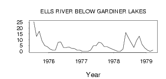
| PointID: | 709 | Code: | 07DA010 | Latitude (decimal degrees): | 57.37 | Longitude (decimal degrees): | -112.56 | Drainage Area (km2): | 1380.00 | Source: | Hydat | Hydrological Zone: | Mackenzie | Name: | ELLS RIVER BELOW GARDINER LAKES |
|---|
| Download | |
|---|---|
| Site Descriptor Information | Site Time Series Data |
| Link to all available data | |
| ID | Year | Jan | Feb | Mar | Apr | May | Jun | Jul | Aug | Sep | Oct | Nov | Dec |
|---|---|---|---|---|---|---|---|---|---|---|---|---|---|
| 709 | 1975 | 25.50 | 12.90 | 17.30 | 9.21 | 5.00 | 4.00 | ||||||
| 709 | 1976 | 2.00 | 1.00 | 1.00 | 8.00 | 8.11 | 3.32 | 3.31 | 3.79 | 2.60 | 2.50 | 1.00 | 1.00 |
| 709 | 1977 | 0.00 | 0.00 | 0.00 | 1.00 | 4.80 | 4.77 | 7.82 | 7.13 | 4.07 | 4.10 | 3.00 | 2.00 |
| 709 | 1978 | 1.00 | 0.00 | 0.00 | 2.00 | 16.20 | 11.60 | 7.31 | 3.37 | 9.41 | 13.10 | 6.00 | 3.00 |
| 709 | 1979 | 1.00 | 0.00 | 1.00 |
 Return to R-Arctic Net Home Page