Kiternya at Boldirevo
Ob
| PointID: | 7072 |
Code: | 11470 |
Latitude (decimal degrees): | 56.32 |
Longitude (decimal degrees): | 70.13 |
Drainage Area (km2): | 1080.00 |
Source: | SHI |
Hydrological Zone: | Ob |
Name: | Kiternya at Boldirevo |
Field Definitions
Site Time Series Plot:
Site Data File:
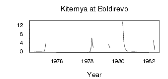
(Units: m3/s)
| ID | Year | Jan | Feb | Mar | Apr | May | Jun | Jul | Aug | Sep | Oct | Nov | Dec |
|---|
| 7072 | 1974 | | | | | | | 0.19 | 0.08 | 0.02 | 0.05 | 9.0e-03 | 0.01 |
| 7072 | 1975 | 0.07 | 0.08 | 0.07 | 3.54 | | | | | | | | |
| 7072 | 1976 | | | | | 0.01 | | | | | | | |
| 7072 | 1978 | | 0.05 | 0.10 | 6.11 | 1.76 | | | | | | | |
| 7072 | 1979 | | | | | 3.14 | 1.69 | | | | | | |
| 7072 | 1980 | | | | 13.60 | 3.78 | 1.31 | 0.39 | 0.12 | | | 0.03 | 0.04 |
| 7072 | 1981 | 0.05 | 0.06 | 0.09 | | 5.95 | | | | | | | |
| 7072 | 1982 | | | | 5.02 | 0.74 | | | | | | | |
 Return to R-Arctic Net Home Page