Bol. Uk at Pospelovo
Ob
| PointID: | 7042 |
Code: | 11383 |
Latitude (decimal degrees): | 56.88 |
Longitude (decimal degrees): | 72.78 |
Drainage Area (km2): | 905.00 |
Source: | SHI |
Hydrological Zone: | Ob |
Name: | Bol. Uk at Pospelovo |
Field Definitions
Site Time Series Plot:
Site Data File:
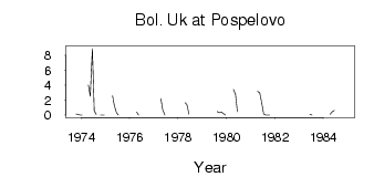
(Units: m3/s)
| ID | Year | Jan | Feb | Mar | Apr | May | Jun | Jul | Aug | Sep | Oct | Nov | Dec |
|---|
| 7042 | 1973 | | | | | | | | | | 0.17 | 0.10 | 0.03 |
| 7042 | 1974 | 0.01 | | | 4.03 | 2.55 | 8.90 | 0.57 | 0.09 | | 8.0e-03 | 0.01 | 7.0e-03 |
| 7042 | 1975 | | | | 2.60 | 1.23 | 0.34 | 0.03 | | | | | |
| 7042 | 1976 | | | | 0.39 | 0.02 | | | | | | | |
| 7042 | 1977 | | | | 2.20 | 0.72 | 0.03 | | | | | | |
| 7042 | 1978 | | | | 1.68 | 1.39 | 0.12 | | | | | | |
| 7042 | 1979 | | | | | | | | 0.49 | 0.35 | 0.41 | 0.24 | 0.02 |
| 7042 | 1980 | | | | 3.47 | 2.80 | 0.49 | | | | | | |
| 7042 | 1981 | 0.01 | | | 3.16 | 3.00 | 1.80 | 0.17 | 0.01 | 0.01 | 3.0e-03 | | |
| 7042 | 1982 | | | | | 0.17 | | | | | | | |
| 7042 | 1983 | | | | | | 0.11 | 6.0e-03 | | | | | |
| 7042 | 1984 | | | | 0.12 | 0.45 | 0.61 | | | | | 0.07 | |
 Return to R-Arctic Net Home Page