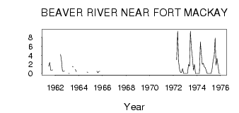
| PointID: | 704 | Code: | 07DA005 | Latitude (decimal degrees): | 57.10 | Longitude (decimal degrees): | -111.63 | Drainage Area (km2): | 454.00 | Source: | Hydat | Hydrological Zone: | Mackenzie | Name: | BEAVER RIVER NEAR FORT MACKAY |
|---|
| Download | |
|---|---|
| Site Descriptor Information | Site Time Series Data |
| Link to all available data | |
| ID | Year | Jan | Feb | Mar | Apr | May | Jun | Jul | Aug | Sep | Oct | Nov | Dec |
|---|---|---|---|---|---|---|---|---|---|---|---|---|---|
| 704 | 1961 | 1.61 | 2.45 | 0.74 | 0.72 | 0.79 | |||||||
| 704 | 1962 | 4.26 | 2.69 | 0.53 | 0.45 | 0.53 | |||||||
| 704 | 1963 | 0.00 | 0.00 | 1.55 | 1.44 | 0.90 | 0.41 | ||||||
| 704 | 1964 | 0.33 | 0.26 | ||||||||||
| 704 | 1965 | 0.50 | 0.15 | 0.46 | 0.45 | ||||||||
| 704 | 1972 | 3.00 | 9.40 | 2.48 | 0.73 | 0.20 | 0.19 | 1.09 | 0.00 | 0.00 | |||
| 704 | 1973 | 0.00 | 0.00 | 0.00 | 2.00 | 1.61 | 9.40 | 5.60 | 3.55 | 0.72 | 2.00 | 0.00 | 0.00 |
| 704 | 1974 | 0.00 | 0.00 | 0.00 | 7.00 | 4.45 | 2.02 | 2.25 | 1.48 | 1.27 | 0.68 | 0.00 | 0.00 |
| 704 | 1975 | 0.00 | 0.00 | 0.00 | 1.00 | 2.88 | 3.77 | 7.84 | 1.83 | 3.35 | 1.64 | 0.00 | 0.00 |
 Return to R-Arctic Net Home Page