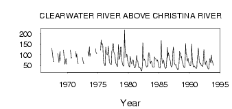
| PointID: | 697 | Code: | 07CD005 | Latitude (decimal degrees): | 56.66 | Longitude (decimal degrees): | -110.92 | Drainage Area (km2): | 17000.00 | Source: | Hydat | Hydrological Zone: | Mackenzie | Name: | CLEARWATER RIVER ABOVE CHRISTINA RIVER |
|---|
| Download | |
|---|---|
| Site Descriptor Information | Site Time Series Data |
| Link to all available data | |
| ID | Year | Jan | Feb | Mar | Apr | May | Jun | Jul | Aug | Sep | Oct | Nov | Dec |
|---|---|---|---|---|---|---|---|---|---|---|---|---|---|
| 697 | 1966 | 116.00 | |||||||||||
| 697 | 1967 | 131.00 | 109.00 | 91.10 | 67.90 | 67.50 | |||||||
| 697 | 1968 | 106.00 | 102.00 | 85.20 | 65.10 | 90.80 | 116.00 | 74.00 | |||||
| 697 | 1969 | 122.00 | 91.00 | 60.70 | 56.10 | 74.30 | 84.10 | 57.00 | |||||
| 697 | 1970 | 123.00 | 114.00 | 84.90 | 87.50 | ||||||||
| 697 | 1971 | 116.00 | 88.80 | 106.00 | 74.00 | 61.70 | 58.50 | ||||||
| 697 | 1972 | 88.50 | 76.90 | 63.70 | 58.40 | ||||||||
| 697 | 1973 | 115.00 | 95.50 | 111.00 | 139.00 | 93.40 | 107.00 | ||||||
| 697 | 1974 | 203.00 | 129.00 | 112.00 | 107.00 | ||||||||
| 697 | 1975 | 122.00 | 170.00 | 148.00 | 154.00 | 150.00 | 91.00 | 61.00 | |||||
| 697 | 1976 | 60.00 | 50.00 | 51.00 | 138.00 | 110.00 | 105.00 | 99.40 | 105.00 | 141.00 | 111.00 | 64.00 | 62.00 |
| 697 | 1977 | 59.00 | 56.00 | 55.00 | 117.00 | 126.00 | 153.00 | 153.00 | 115.00 | 104.00 | 101.00 | 73.00 | 60.00 |
| 697 | 1978 | 54.00 | 51.00 | 45.00 | 75.00 | 149.00 | 110.00 | 79.30 | 92.30 | 137.00 | 138.00 | 82.00 | 69.00 |
| 697 | 1979 | 56.00 | 51.00 | 47.00 | 58.00 | 218.00 | 135.00 | 110.00 | 88.40 | 104.00 | 99.00 | 72.00 | 65.00 |
| 697 | 1980 | 54.00 | 46.00 | 44.00 | 94.00 | 80.80 | 65.80 | 57.30 | 69.30 | 77.00 | 75.80 | 55.00 | 41.00 |
| 697 | 1981 | 39.00 | 42.00 | 45.00 | 83.00 | 97.40 | 75.70 | 69.80 | 48.30 | 40.80 | 44.00 | 43.00 | 35.00 |
| 697 | 1982 | 33.00 | 26.00 | 25.00 | 48.00 | 158.00 | 85.50 | 73.90 | 80.90 | 73.20 | 66.70 | 52.00 | 44.00 |
| 697 | 1983 | 44.00 | 50.00 | 47.00 | 102.00 | 111.00 | 98.90 | 68.90 | 59.10 | 70.90 | 68.80 | 58.00 | 46.00 |
| 697 | 1984 | 42.00 | 42.00 | 43.00 | 91.00 | 83.30 | 82.40 | 77.70 | 72.70 | 71.00 | 77.00 | 62.00 | 47.00 |
| 697 | 1985 | 41.00 | 39.00 | 38.00 | 86.00 | 168.00 | 90.10 | 68.30 | 59.10 | 68.50 | 75.90 | 58.00 | 42.00 |
| 697 | 1986 | 42.00 | 36.00 | 40.00 | 80.00 | 136.00 | 87.90 | 111.00 | 103.00 | 80.20 | 79.40 | 72.00 | 52.00 |
| 697 | 1987 | 43.00 | 47.00 | 50.00 | 119.00 | 138.00 | 96.90 | 61.40 | 55.50 | 52.20 | 54.90 | 44.00 | 40.00 |
| 697 | 1988 | 33.00 | 30.00 | 36.00 | 59.00 | 117.00 | 109.00 | 108.00 | 87.30 | 93.80 | 73.30 | 63.00 | 58.00 |
| 697 | 1989 | 46.00 | 41.00 | 41.00 | 63.00 | 154.00 | 105.00 | 102.00 | 71.50 | 72.50 | 84.80 | 67.00 | 59.00 |
| 697 | 1990 | 54.00 | 48.00 | 50.00 | 97.00 | 151.00 | 89.50 | 63.60 | 45.10 | 43.80 | 48.00 | 45.00 | 42.00 |
| 697 | 1991 | 38.00 | 37.00 | 39.00 | 93.00 | 100.00 | 133.00 | 104.00 | 67.00 | 63.60 | 57.70 | 61.00 | 50.00 |
| 697 | 1992 | 51.00 | 48.00 | 45.00 | 88.00 | 125.00 | 94.80 | 66.20 | 54.80 | 67.00 | 72.00 | 56.00 | 42.00 |
| 697 | 1993 | 36.00 | 34.00 | 37.00 | 75.00 | 83.70 | 67.00 | 63.10 | 98.80 | 73.60 | 70.20 | 58.00 | 51.00 |
 Return to R-Arctic Net Home Page