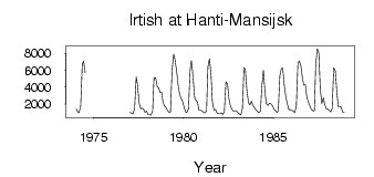
Irtish at Hanti-Mansijsk
Ob
| PointID: | 6954 |
Code: | 11061 |
Latitude (decimal degrees): | 60.97 |
Longitude (decimal degrees): | 69.07 |
Drainage Area (km2): | 1200000.00 |
Source: | SHI |
Hydrological Zone: | Ob |
Name: | Irtish at Hanti-Mansijsk |
Field Definitions
Site Time Series Plot:
Site Data File:
(Units: m3/s)
| ID | Year | Jan | Feb | Mar | Apr | May | Jun | Jul | Aug | Sep | Oct | Nov | Dec |
|---|
| 6954 | 1974 | 1410.00 | 1020.00 | 962.00 | 1790.00 | 6730.00 | 7090.00 | 5710.00 | | | | | |
| 6954 | 1977 | 999.00 | 872.00 | 821.00 | 1450.00 | 5220.00 | 4290.00 | 2130.00 | 1410.00 | 1490.00 | 1370.00 | 989.00 | 1160.00 |
| 6954 | 1978 | 720.00 | 704.00 | 690.00 | 1190.00 | 5090.00 | 5140.00 | 4090.00 | 3920.00 | 3350.00 | 3390.00 | 2160.00 | 1720.00 |
| 6954 | 1979 | 1610.00 | 1220.00 | 988.00 | 1020.00 | 5940.00 | 7910.00 | 7270.00 | 5990.00 | 4260.00 | 3250.00 | 2660.00 | 2340.00 |
| 6954 | 1980 | 1670.00 | 1070.00 | 992.00 | 1410.00 | 6000.00 | 7150.00 | 5250.00 | 2790.00 | 2420.00 | 2200.00 | 1260.00 | 1240.00 |
| 6954 | 1981 | 1200.00 | 991.00 | 932.00 | 1180.00 | 6390.00 | 7380.00 | 5420.00 | 2230.00 | 1280.00 | 1360.00 | 934.00 | 831.00 |
| 6954 | 1982 | 850.00 | 947.00 | 753.00 | 1130.00 | 4640.00 | 4370.00 | 2680.00 | 1770.00 | 1350.00 | 1140.00 | 1180.00 | 1200.00 |
| 6954 | 1983 | 968.00 | 810.00 | 672.00 | 1500.00 | 6330.00 | 6090.00 | 3550.00 | 2150.00 | 1870.00 | 2310.00 | 1790.00 | 1590.00 |
| 6954 | 1984 | 1290.00 | 1110.00 | 956.00 | 1120.00 | 4070.00 | 6000.00 | 3350.00 | 2070.00 | 1830.00 | 2090.00 | 2000.00 | 1800.00 |
| 6954 | 1985 | 1370.00 | 1220.00 | 1010.00 | 1170.00 | 5350.00 | 6230.00 | 6250.00 | 4120.00 | 2770.00 | 2010.00 | 1310.00 | 1330.00 |
| 6954 | 1986 | 1220.00 | 1120.00 | 979.00 | 1750.00 | 6780.00 | 7110.00 | 6580.00 | 5070.00 | 4240.00 | 4280.00 | 2720.00 | 2260.00 |
| 6954 | 1987 | 1740.00 | 1370.00 | 1200.00 | 1190.00 | 6530.00 | 8580.00 | 8040.00 | 3840.00 | 2050.00 | 2730.00 | 1940.00 | 1430.00 |
| 6954 | 1988 | 1370.00 | 1230.00 | 1050.00 | 1480.00 | 6300.00 | 5920.00 | 3660.00 | 1660.00 | 1720.00 | 1610.00 | 999.00 | 1010.00 |
| Other Close Sites |
|---|
| PointID |
Latitude |
Longitude | Drainage Area | Source |
Name |
|---|
| 6666 | 61.07 | 68.60 | 2160000.00 | SHI | Ob at Belogorje |
 Return to R-Arctic Net Home Page