Yr at Podgornoje
Ob
| PointID: | 6941 |
Code: | 10653 |
Latitude (decimal degrees): | 54.50 |
Longitude (decimal degrees): | 86.00 |
Drainage Area (km2): | 1185.00 |
Source: | SHI |
Hydrological Zone: | Ob |
Name: | Yr at Podgornoje |
Field Definitions
Site Time Series Plot:
Site Data File:
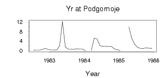
(Units: m3/s)
| ID | Year | Jan | Feb | Mar | Apr | May | Jun | Jul | Aug | Sep | Oct | Nov | Dec |
|---|
| 6941 | 1982 | | | | | | | 0.27 | 0.20 | 0.21 | 0.55 | 0.98 | 0.57 |
| 6941 | 1983 | 0.31 | 0.30 | 0.25 | 2.05 | 12.20 | 1.52 | 0.68 | 0.66 | 0.63 | 0.85 | 0.70 | 0.69 |
| 6941 | 1984 | 0.03 | | 0.01 | 5.23 | 4.91 | 2.10 | 1.83 | 1.86 | 1.71 | 1.82 | 0.77 | 0.45 |
| 6941 | 1985 | 0.05 | | | 9.91 | 5.29 | 2.71 | 1.45 | 0.99 | 0.96 | 1.25 | 1.05 | 0.99 |
 Return to R-Arctic Net Home Page