Miltyush at Ulibino
Ob
| PointID: | 6938 |
Code: | 10626 |
Latitude (decimal degrees): | 54.58 |
Longitude (decimal degrees): | 82.92 |
Drainage Area (km2): | 514.00 |
Source: | SHI |
Hydrological Zone: | Ob |
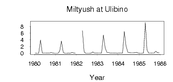
Name: | Miltyush at Ulibino |
Field Definitions
Site Time Series Plot:
Site Data File:
(Units: m3/s)
| ID | Year | Jan | Feb | Mar | Apr | May | Jun | Jul | Aug | Sep | Oct | Nov | Dec |
|---|
| 6938 | 1980 | 0.04 | 0.01 | 0.02 | 3.96 | 0.12 | 0.04 | 0.05 | 0.11 | 0.05 | 0.25 | 0.14 | 0.03 |
| 6938 | 1981 | 0.02 | 0.02 | 0.66 | 3.68 | 0.29 | 0.02 | 0.03 | 0.07 | 0.03 | 0.28 | 0.14 | 0.01 |
| 6938 | 1982 | | | | 6.72 | 0.44 | 0.03 | 0.03 | 0.03 | 0.06 | 0.43 | 0.05 | 0.09 |
| 6938 | 1983 | 0.06 | 0.06 | 0.08 | 5.46 | 1.70 | 0.33 | 0.25 | 0.09 | 0.07 | 0.14 | 0.08 | 0.03 |
| 6938 | 1984 | 0.08 | 0.05 | 0.10 | 6.51 | 2.19 | 0.31 | 0.22 | 0.17 | 0.15 | 0.19 | 0.31 | 0.07 |
| 6938 | 1985 | 0.03 | 0.03 | 0.14 | 9.14 | 0.97 | 0.07 | 0.07 | 0.08 | 0.08 | 0.64 | 0.22 | 0.17 |
 Return to R-Arctic Net Home Page