Kulunda at Bajevo
Ob
| PointID: | 6937 |
Code: | 10625 |
Latitude (decimal degrees): | 53.27 |
Longitude (decimal degrees): | 80.78 |
Drainage Area (km2): | 8720.00 |
Source: | SHI |
Hydrological Zone: | Ob |
Name: | Kulunda at Bajevo |
Field Definitions
Site Time Series Plot:
Site Data File:
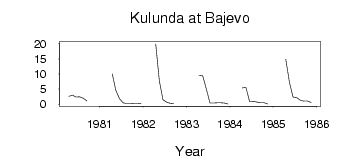
(Units: m3/s)
| ID | Year | Jan | Feb | Mar | Apr | May | Jun | Jul | Aug | Sep | Oct | Nov | Dec |
|---|
| 6937 | 1980 | | | | 2.64 | 3.03 | 2.33 | 2.43 | 1.93 | 1.11 | | | 0.33 |
| 6937 | 1981 | | | | 10.00 | 4.51 | 1.78 | 0.48 | 0.23 | 0.20 | 0.33 | 0.32 | 0.13 |
| 6937 | 1982 | | | | 19.90 | 7.72 | 1.50 | 0.67 | 0.29 | 0.25 | | | |
| 6937 | 1983 | | | | 9.51 | 9.32 | 4.96 | 0.40 | 0.38 | 0.48 | 0.44 | 0.41 | 0.08 |
| 6937 | 1984 | | | | 5.40 | 5.57 | 0.86 | 0.93 | 0.70 | 0.47 | 0.49 | 0.04 | |
| 6937 | 1985 | | | | 14.80 | 7.29 | 2.36 | 2.18 | 1.33 | 0.99 | 0.98 | 0.54 | |
 Return to R-Arctic Net Home Page