Uta at Primetkino
Ob
| PointID: | 6932 |
Code: | 10620 |
Latitude (decimal degrees): | 56.68 |
Longitude (decimal degrees): | 87.92 |
Drainage Area (km2): | 200.00 |
Source: | SHI |
Hydrological Zone: | Ob |
Name: | Uta at Primetkino |
Field Definitions
Site Time Series Plot:
Site Data File:
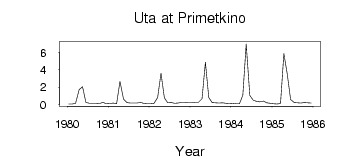
(Units: m3/s)
| ID | Year | Jan | Feb | Mar | Apr | May | Jun | Jul | Aug | Sep | Oct | Nov | Dec |
|---|
| 6932 | 1980 | 0.06 | 0.04 | 0.12 | 1.71 | 2.03 | 0.25 | 0.12 | 0.13 | 0.12 | 0.11 | 0.24 | 0.09 |
| 6932 | 1981 | 0.10 | 0.15 | 0.09 | 2.66 | 0.61 | 0.22 | 0.17 | 0.16 | 0.16 | 0.23 | 0.11 | 0.07 |
| 6932 | 1982 | 0.07 | 0.14 | 0.80 | 3.59 | 0.76 | 0.20 | 0.21 | 0.13 | 0.15 | 0.25 | 0.24 | 0.20 |
| 6932 | 1983 | 0.20 | 0.24 | 0.23 | 0.66 | 4.88 | 0.79 | 0.21 | 0.18 | 0.17 | 0.18 | 0.13 | 0.11 |
| 6932 | 1984 | 0.13 | 0.09 | 0.09 | 1.07 | 6.98 | 1.04 | 0.48 | 0.34 | 0.31 | 0.38 | 0.20 | 0.13 |
| 6932 | 1985 | 0.08 | 0.06 | 0.11 | 5.87 | 3.50 | 0.58 | 0.22 | 0.20 | 0.17 | 0.21 | 0.19 | 0.17 |
 Return to R-Arctic Net Home Page