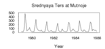
| PointID: | 6924 | Code: | 10589 | Latitude (decimal degrees): | 54.37 | Longitude (decimal degrees): | 87.63 | Drainage Area (km2): | 1780.00 | Source: | SHI | Hydrological Zone: | Ob | Name: | Srednyaya Ters at Mutnoje |
|---|
| Download | |
|---|---|
| Site Descriptor Information | Site Time Series Data |
| Link to all available data | |
| ID | Year | Jan | Feb | Mar | Apr | May | Jun | Jul | Aug | Sep | Oct | Nov | Dec |
|---|---|---|---|---|---|---|---|---|---|---|---|---|---|
| 6924 | 1979 | 12.50 | 10.10 | 7.69 | 67.60 | 484.00 | 282.00 | 31.00 | 53.70 | 65.40 | 123.00 | 46.00 | 20.20 |
| 6924 | 1980 | 20.20 | 15.80 | 13.50 | 149.00 | 334.00 | 109.00 | 66.60 | 44.30 | 36.10 | 29.70 | 54.70 | 15.10 |
| 6924 | 1981 | 8.67 | 8.13 | 11.00 | 146.00 | 276.00 | 59.40 | 19.30 | 20.10 | 29.60 | 45.90 | 9.13 | 11.20 |
| 6924 | 1982 | 9.38 | 7.33 | 8.22 | 124.00 | 230.00 | 46.30 | 20.60 | 13.10 | 14.40 | 81.90 | 38.70 | 21.20 |
| 6924 | 1983 | 16.60 | 14.10 | 13.00 | 62.90 | 253.00 | 230.00 | 21.50 | 24.30 | 50.70 | 84.40 | 56.30 | 24.30 |
| 6924 | 1984 | 20.60 | 14.50 | 12.40 | 43.00 | 299.00 | 177.00 | 46.80 | 31.30 | 16.60 | 60.70 | 45.80 | 11.90 |
| 6924 | 1985 | 9.97 | 9.57 | 9.83 | 94.60 | 265.00 | 232.00 | 35.10 | 72.90 | 54.70 | 45.80 | 52.60 | 19.50 |
 Return to R-Arctic Net Home Page