Tisulka at Tisul'
Ob
| PointID: | 6920 |
Code: | 10584 |
Latitude (decimal degrees): | 55.75 |
Longitude (decimal degrees): | 88.32 |
Drainage Area (km2): | 217.00 |
Source: | SHI |
Hydrological Zone: | Ob |
Name: | Tisulka at Tisul' |
Field Definitions
Site Time Series Plot:
Site Data File:
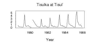
(Units: m3/s)
| ID | Year | Jan | Feb | Mar | Apr | May | Jun | Jul | Aug | Sep | Oct | Nov | Dec |
|---|
| 6920 | 1978 | | | | | | | | 0.73 | 0.24 | 0.22 | 0.15 | 0.14 |
| 6920 | 1979 | 0.12 | 0.10 | 0.08 | 1.32 | 4.42 | 0.68 | 0.30 | 0.50 | 0.50 | 0.64 | 0.33 | 0.21 |
| 6920 | 1980 | 0.12 | 0.03 | | 2.58 | 2.30 | 1.83 | 1.50 | 0.96 | 0.76 | 0.35 | 0.32 | 0.18 |
| 6920 | 1981 | 0.19 | 0.11 | 0.46 | 2.91 | 0.79 | 0.32 | 0.24 | 0.22 | 0.63 | 0.41 | 0.21 | 0.11 |
| 6920 | 1982 | 0.12 | 0.10 | 0.22 | 3.32 | 1.50 | 0.48 | 0.68 | 0.27 | 0.20 | 0.42 | 0.26 | 0.16 |
| 6920 | 1983 | 0.17 | 0.17 | 0.24 | 1.85 | 4.39 | 1.05 | 0.62 | 0.54 | 0.70 | 0.30 | 0.44 | 0.23 |
| 6920 | 1984 | 0.11 | 0.08 | 0.08 | 2.67 | 4.55 | 1.23 | 1.13 | 0.85 | 0.64 | 0.67 | 0.42 | 0.21 |
| 6920 | 1985 | 0.12 | 0.11 | 0.12 | 4.44 | 5.47 | 2.02 | 1.55 | 0.84 | 0.75 | 0.90 | 0.59 | 0.17 |
 Return to R-Arctic Net Home Page