| PointID: | 6919 | Code: | 10583 | Latitude (decimal degrees): | 56.12 | Longitude (decimal degrees): | 86.45 | Drainage Area (km2): | 2900.00 | Source: | SHI | Hydrological Zone: | Ob | Name: | Zolotoj Kitat at Maltsevo |
|---|
| Download | |
|---|---|
| Site Descriptor Information | Site Time Series Data |
| Link to all available data | |
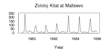
| ID | Year | Jan | Feb | Mar | Apr | May | Jun | Jul | Aug | Sep | Oct | Nov | Dec |
|---|---|---|---|---|---|---|---|---|---|---|---|---|---|
| 6919 | 1979 | 4.49 | 3.29 | 3.36 | 16.10 | 246.00 | 20.00 | 4.92 | 9.73 | 7.95 | 26.40 | 17.60 | 7.12 |
| 6919 | 1980 | 4.73 | 3.42 | 2.91 | 71.30 | 90.10 | 11.60 | 9.23 | 7.01 | 4.44 | 5.25 | 13.60 | 4.69 |
| 6919 | 1981 | 3.12 | 2.58 | 3.50 | 99.80 | 37.80 | 7.36 | 3.99 | 3.28 | 3.00 | 5.76 | 3.29 | 2.74 |
| 6919 | 1982 | 2.09 | 1.86 | 1.98 | 120.00 | 50.60 | 6.94 | 4.61 | 3.84 | 3.56 | 18.80 | 15.90 | 6.44 |
| 6919 | 1983 | 7.15 | 7.13 | 6.35 | 18.20 | 224.00 | 25.10 | 4.95 | 4.41 | 4.01 | 5.81 | 10.20 | 5.95 |
| 6919 | 1984 | 3.03 | 2.14 | 2.36 | 13.00 | 213.00 | 22.10 | 12.10 | 4.83 | 3.69 | 8.82 | 11.20 | 3.86 |
| 6919 | 1985 | 2.44 | 2.63 | 2.83 | 60.30 | 184.00 | 41.00 | 9.02 | 14.40 | 11.90 | 21.80 | 27.70 | 7.76 |
 Return to R-Arctic Net Home Page