Modjarka at Modjari
Ob
| PointID: | 6914 |
Code: | 10577 |
Latitude (decimal degrees): | 55.53 |
Longitude (decimal degrees): | 89.63 |
Drainage Area (km2): | 83.90 |
Source: | SHI |
Hydrological Zone: | Ob |
Name: | Modjarka at Modjari |
Field Definitions
Site Time Series Plot:
Site Data File:
(Units: m3/s)
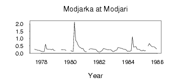
| ID | Year | Jan | Feb | Mar | Apr | May | Jun | Jul | Aug | Sep | Oct | Nov | Dec |
|---|
| 6914 | 1977 | | | | | | | 0.28 | 0.24 | 0.22 | 0.20 | 0.19 | 0.15 |
| 6914 | 1978 | 0.12 | 0.11 | 0.12 | 0.62 | 0.29 | 0.28 | 0.26 | 0.26 | 0.24 | 0.29 | 0.19 | 0.19 |
| 6914 | 1979 | | | | | 0.25 | 0.23 | 0.24 | 0.24 | 0.19 | | | |
| 6914 | 1980 | 0.18 | 0.13 | 0.12 | 2.14 | 0.88 | 0.77 | 0.55 | 0.43 | 0.39 | 0.31 | 0.33 | 0.18 |
| 6914 | 1981 | 0.10 | 0.11 | | 0.25 | 0.30 | 0.30 | 0.29 | 0.28 | 0.27 | 0.24 | 0.13 | 0.08 |
| 6914 | 1982 | 0.08 | 0.13 | 0.19 | 0.32 | 0.30 | 0.28 | 0.25 | 0.24 | 0.25 | 0.25 | 0.17 | 0.11 |
| 6914 | 1983 | 0.13 | 0.20 | 0.21 | 0.39 | 0.37 | 0.35 | 0.34 | 0.30 | 0.27 | 0.26 | 0.21 | 0.12 |
| 6914 | 1984 | 0.15 | 0.13 | 0.17 | 1.13 | 0.42 | 0.44 | 0.45 | 0.27 | 0.27 | 0.25 | 0.18 | 0.16 |
| 6914 | 1985 | 0.21 | 0.16 | 0.18 | | 0.49 | 0.67 | 0.55 | 0.46 | 0.44 | 0.44 | 0.38 | 0.29 |
 Return to R-Arctic Net Home Page