| PointID: | 691 | Code: | 07CA013 | Latitude (decimal degrees): | 55.01 | Longitude (decimal degrees): | -111.85 | Drainage Area (km2): | 3080.00 | Source: | Hydat | Hydrological Zone: | Mackenzie | Name: | OWL RIVER BELOW PICHE RIVER |
|---|
| Download | |
|---|---|
| Site Descriptor Information | Site Time Series Data |
| Link to all available data | |
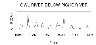
| ID | Year | Jan | Feb | Mar | Apr | May | Jun | Jul | Aug | Sep | Oct | Nov | Dec |
|---|---|---|---|---|---|---|---|---|---|---|---|---|---|
| 691 | 1984 | 1.00 | 6.00 | 7.27 | 9.91 | 9.19 | 4.15 | 4.89 | 5.13 | ||||
| 691 | 1985 | 1.00 | 6.00 | 25.70 | 12.10 | 6.18 | 2.53 | 1.65 | 2.10 | ||||
| 691 | 1986 | 1.00 | 5.00 | 6.30 | 5.08 | 10.20 | 11.90 | 3.66 | 2.50 | ||||
| 691 | 1987 | 1.00 | 7.00 | 9.06 | 7.41 | 3.84 | 2.50 | 1.49 | 1.23 | ||||
| 691 | 1988 | 0.00 | 4.00 | 5.21 | 5.50 | 6.29 | 2.61 | 1.44 | 1.56 | ||||
| 691 | 1989 | 0.00 | 3.00 | 6.35 | 9.74 | 8.24 | 5.70 | 6.53 | 5.50 | ||||
| 691 | 1990 | 2.00 | 7.00 | 20.40 | 11.50 | 6.67 | |||||||
| 691 | 1991 | 0.00 | 3.00 | 3.40 | 6.86 | 5.95 | 1.07 | 1.13 | 1.26 | ||||
| 691 | 1992 | 1.00 | 2.00 | 3.29 | 3.08 | 1.13 | 1.34 | 0.95 | 0.87 | ||||
| 691 | 1993 | 0.00 | 1.00 | 1.78 | 1.77 | 3.66 | 6.17 | 3.42 | 2.62 |
 Return to R-Arctic Net Home Page