| PointID: | 6907 | Code: | 10568 | Latitude (decimal degrees): | 57.17 | Longitude (decimal degrees): | 84.13 | Drainage Area (km2): | 517.00 | Source: | SHI | Hydrological Zone: | Ob | Name: | Minger at Ishtan |
|---|
| Download | |
|---|---|
| Site Descriptor Information | Site Time Series Data |
| Link to all available data | |
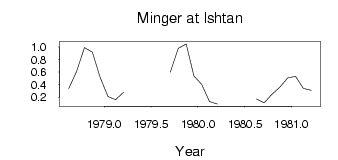
| ID | Year | Jan | Feb | Mar | Apr | May | Jun | Jul | Aug | Sep | Oct | Nov | Dec |
|---|---|---|---|---|---|---|---|---|---|---|---|---|---|
| 6907 | 1978 | 0.34 | 0.61 | 0.99 | 0.92 | 0.52 | |||||||
| 6907 | 1979 | 0.21 | 0.16 | 0.28 | 0.60 | 0.98 | 1.05 | 0.54 | |||||
| 6907 | 1980 | 0.40 | 0.13 | 0.09 | 0.17 | 0.11 | 0.25 | 0.36 | 0.51 | ||||
| 6907 | 1981 | 0.53 | 0.34 | 0.31 |
 Return to R-Arctic Net Home Page