Toya at Vorob'i
Ob
| PointID: | 6903 |
Code: | 10562 |
Latitude (decimal degrees): | 55.97 |
Longitude (decimal degrees): | 81.52 |
Drainage Area (km2): | 1510.00 |
Source: | SHI |
Hydrological Zone: | Ob |
Name: | Toya at Vorob'i |
Field Definitions
Site Time Series Plot:
Site Data File:
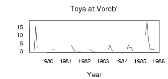
(Units: m3/s)
| ID | Year | Jan | Feb | Mar | Apr | May | Jun | Jul | Aug | Sep | Oct | Nov | Dec |
|---|
| 6903 | 1979 | | | | 0.88 | 15.70 | 2.18 | | | | | | |
| 6903 | 1980 | | | | 1.08 | 1.28 | | | | | | | |
| 6903 | 1981 | | | | 3.83 | 1.95 | 0.38 | 0.08 | 0.08 | 0.08 | 0.07 | | |
| 6903 | 1982 | | | | 1.12 | 0.40 | 0.09 | 0.02 | | | | | |
| 6903 | 1983 | | | | 1.16 | 3.89 | 1.04 | 0.04 | | | | | |
| 6903 | 1984 | | | | 0.81 | 3.76 | 2.12 | 2.41 | 0.06 | | | | |
| 6903 | 1985 | | | | 10.30 | 18.30 | 6.38 | 1.77 | 1.14 | 1.23 | 0.80 | | |
 Return to R-Arctic Net Home Page