| PointID: | 69 | Code: | 05AC024 | Latitude (decimal degrees): | 50.58 | Longitude (decimal degrees): | -112.92 | Drainage Area (km2): | Source: | Hydat | Hydrological Zone: | Nelson | Name: | MCGREGOR LAKE INFLOW NEAR MILO |
|---|
| Download | |
|---|---|
| Site Descriptor Information | Site Time Series Data |
| Link to all available data | |
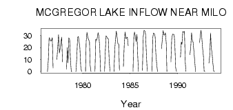
| ID | Year | Jan | Feb | Mar | Apr | May | Jun | Jul | Aug | Sep | Oct | Nov | Dec |
|---|---|---|---|---|---|---|---|---|---|---|---|---|---|
| 69 | 1976 | 0.00 | 9.15 | 28.30 | 27.40 | 25.50 | 25.70 | 28.20 | 3.00 | ||||
| 69 | 1977 | 10.00 | 20.60 | 30.80 | 15.40 | 19.50 | 23.80 | 28.70 | 8.00 | ||||
| 69 | 1978 | 2.00 | 20.00 | 7.33 | 28.10 | 26.70 | 9.54 | 0.03 | 0.00 | ||||
| 69 | 1979 | 0.00 | 10.80 | 28.40 | 29.20 | 25.10 | 19.70 | 4.32 | 0.00 | ||||
| 69 | 1980 | 0.00 | 25.20 | 32.60 | 28.20 | 26.60 | 24.70 | 5.27 | 0.00 | ||||
| 69 | 1981 | 0.00 | 26.90 | 26.00 | 28.10 | 32.40 | 29.40 | 19.80 | 0.00 | ||||
| 69 | 1982 | 0.00 | 14.80 | 29.80 | 28.80 | 27.50 | 27.30 | 9.57 | 0.00 | ||||
| 69 | 1983 | 0.00 | 18.90 | 26.80 | 33.80 | 28.60 | 23.00 | 23.00 | 1.00 | ||||
| 69 | 1984 | 4.00 | 21.90 | 32.90 | 27.40 | 28.00 | 28.70 | 21.50 | |||||
| 69 | 1985 | 0.00 | 28.60 | 33.00 | 29.70 | 25.00 | 31.00 | 14.90 | 0.00 | ||||
| 69 | 1986 | 1.00 | 29.20 | 34.50 | 33.70 | 31.20 | 14.70 | 0.22 | |||||
| 69 | 1987 | 0.00 | 28.00 | 32.10 | 31.50 | 29.00 | 15.30 | 6.64 | 0.00 | ||||
| 69 | 1988 | 19.00 | 26.20 | 34.20 | 30.90 | 30.30 | 32.20 | 23.60 | 0.00 | ||||
| 69 | 1989 | 8.00 | 27.10 | 31.20 | 31.00 | 30.80 | 22.00 | 3.02 | 0.00 | ||||
| 69 | 1990 | 12.00 | 24.70 | 22.70 | 33.30 | 32.80 | 33.50 | 7.67 | 0.00 | ||||
| 69 | 1991 | 14.00 | 20.50 | 32.20 | 25.80 | 24.70 | 17.30 | 9.09 | 0.00 | ||||
| 69 | 1992 | 24.00 | 29.00 | 34.40 | 28.10 | 19.10 | 12.50 | 0.30 | 0.00 | ||||
| 69 | 1993 | 7.00 | 13.50 | 32.10 | 20.00 | 15.00 | 6.76 | 0.19 | 0.00 |
 Return to R-Arctic Net Home Page