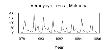
| PointID: | 6899 | Code: | 10555 | Latitude (decimal degrees): | 54.20 | Longitude (decimal degrees): | 87.83 | Drainage Area (km2): | 655.00 | Source: | SHI | Hydrological Zone: | Ob | Name: | Verhnyaya Ters at Makariha |
|---|
| Download | |
|---|---|
| Site Descriptor Information | Site Time Series Data |
| Link to all available data | |
| ID | Year | Jan | Feb | Mar | Apr | May | Jun | Jul | Aug | Sep | Oct | Nov | Dec |
|---|---|---|---|---|---|---|---|---|---|---|---|---|---|
| 6899 | 1978 | 1.84 | 1.67 | 2.01 | 72.20 | 124.00 | 107.00 | 27.80 | 24.70 | 18.10 | 22.30 | 16.00 | 14.60 |
| 6899 | 1979 | 9.28 | 4.65 | 6.12 | 43.90 | 194.00 | 120.00 | 20.40 | 25.60 | 45.30 | 80.00 | 23.20 | 6.60 |
| 6899 | 1980 | 4.97 | 3.70 | 3.98 | 63.00 | 161.00 | 72.30 | 45.10 | 36.40 | 37.10 | 32.40 | 53.20 | 18.00 |
| 6899 | 1981 | 6.91 | 2.69 | 2.11 | 60.50 | 140.00 | 47.70 | 13.20 | 8.96 | 14.80 | 18.10 | 4.44 | 3.80 |
| 6899 | 1982 | 2.81 | 1.98 | 2.26 | 58.90 | 118.00 | 33.40 | 10.60 | 10.60 | 14.60 | 50.20 | 8.49 | 3.16 |
| 6899 | 1983 | 2.17 | 2.45 | 3.01 | 40.40 | 118.00 | 119.00 | 21.00 | 18.30 | 33.10 | 41.40 | 33.40 | 2.59 |
| 6899 | 1984 | 2.06 | 1.87 | 1.84 | 28.70 | 138.00 | 93.60 | 22.90 | 16.70 | 11.00 | 16.50 | 8.99 | 3.56 |
| 6899 | 1985 | 4.05 | 6.45 | 5.86 | 43.90 | 106.00 | 112.00 | 18.50 | 26.40 | 17.90 | 14.60 | 8.40 | 1.05 |
 Return to R-Arctic Net Home Page