| PointID: | 6896 | Code: | 10552 | Latitude (decimal degrees): | 53.30 | Longitude (decimal degrees): | 84.20 | Drainage Area (km2): | 1320.00 | Source: | SHI | Hydrological Zone: | Ob | Name: | Bolshaya Losiha at Bayunovskije Kl |
|---|
| Download | |
|---|---|
| Site Descriptor Information | Site Time Series Data |
| Link to all available data | |
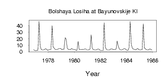
| ID | Year | Jan | Feb | Mar | Apr | May | Jun | Jul | Aug | Sep | Oct | Nov | Dec |
|---|---|---|---|---|---|---|---|---|---|---|---|---|---|
| 6896 | 1976 | 3.35 | 2.01 | ||||||||||
| 6896 | 1977 | 1.64 | 2.41 | 2.27 | 46.60 | 8.70 | 3.70 | 2.99 | 3.03 | 3.48 | 4.79 | 3.87 | 2.31 |
| 6896 | 1978 | 3.15 | 3.41 | 3.77 | 40.10 | 7.11 | 5.67 | 3.50 | 3.45 | 3.88 | 4.58 | 5.09 | 4.84 |
| 6896 | 1979 | 3.40 | 4.09 | 3.81 | 21.60 | 19.50 | 5.62 | 3.85 | 3.31 | 3.47 | 5.05 | 4.02 | 3.75 |
| 6896 | 1980 | 3.63 | 2.46 | 2.16 | 15.80 | 3.59 | 3.38 | 3.27 | 3.92 | 3.69 | 4.27 | 4.65 | 3.00 |
| 6896 | 1981 | 2.87 | 3.14 | 4.15 | 25.90 | 6.09 | 3.29 | 3.16 | 2.92 | 3.10 | 4.20 | 4.14 | 2.66 |
| 6896 | 1982 | 2.22 | 1.90 | 1.86 | 44.40 | 7.55 | 3.77 | 2.77 | 2.69 | 2.91 | 4.46 | 4.58 | 3.77 |
| 6896 | 1983 | 3.28 | 3.42 | 4.29 | 16.50 | 9.00 | 4.21 | 3.11 | 2.75 | 3.41 | 4.64 | 4.86 | 3.82 |
| 6896 | 1984 | 2.32 | 2.36 | 6.56 | 46.30 | 11.20 | 5.57 | 4.02 | 3.79 | 2.94 | 4.19 | 5.16 | 3.37 |
| 6896 | 1985 | 2.95 | 3.09 | 3.15 | 42.90 | 6.12 | 4.57 | 3.31 | 2.87 | 3.08 | 4.33 | 3.85 | 2.52 |
 Return to R-Arctic Net Home Page