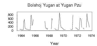
| PointID: | 6880 | Code: | 10506 | Latitude (decimal degrees): | 60.67 | Longitude (decimal degrees): | 73.82 | Drainage Area (km2): | 33000.00 | Source: | SHI | Hydrological Zone: | Ob | Name: | Bolshoj Yugan at Yugan Pzu |
|---|
| Download | |
|---|---|
| Site Descriptor Information | Site Time Series Data |
| Link to all available data | |
| ID | Year | Jan | Feb | Mar | Apr | May | Jun | Jul | Aug | Sep | Oct | Nov | Dec |
|---|---|---|---|---|---|---|---|---|---|---|---|---|---|
| 6880 | 1963 | 49.40 | 51.10 | 43.60 | |||||||||
| 6880 | 1964 | 36.30 | 32.10 | 27.00 | 26.90 | 480.00 | 560.00 | 140.00 | 79.10 | 65.80 | 59.90 | 40.50 | 39.30 |
| 6880 | 1965 | 33.40 | 24.90 | 29.20 | 33.60 | 753.00 | 774.00 | 252.00 | 306.00 | 553.00 | |||
| 6880 | 1967 | 472.00 | 172.00 | 93.70 | 112.00 | 48.80 | 116.00 | ||||||
| 6880 | 1968 | 64.50 | 611.00 | 528.00 | 96.00 | 52.40 | 31.20 | ||||||
| 6880 | 1969 | 24.80 | 22.20 | 22.50 | 25.00 | 334.00 | 906.00 | 622.00 | 241.00 | 138.00 | 144.00 | 116.00 | 81.70 |
| 6880 | 1970 | 44.10 | 34.70 | 32.30 | 37.30 | ||||||||
| 6880 | 1971 | 62.40 | 40.60 | 30.40 | 40.00 | 782.00 | 129.00 | 127.00 | 122.00 | 88.70 | |||
| 6880 | 1972 | 45.20 | 33.20 | 31.70 | 41.20 | 622.00 | 604.00 | 554.00 | 146.00 | 125.00 | 107.00 | 71.20 | |
| 6880 | 1973 | 141.00 | 863.00 | 518.00 | 423.00 | 336.00 | 166.00 |
| Other Close Sites | ||||||
|---|---|---|---|---|---|---|
| PointID | Latitude | Longitude | Drainage Area | Source | Name | |
| 6878 | 60.27 | 73.82 | 18300.00 | SHI | Bolshoj Yugan at Riskini | |
| 6879 | 60.50 | 74.02 | 22100.00 | SHI | Bolshoj Yugan at Ugut | |
 Return to R-Arctic Net Home Page