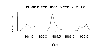
| PointID: | 688 | Code: | 07CA010 | Latitude (decimal degrees): | 55.00 | Longitude (decimal degrees): | -111.71 | Drainage Area (km2): | 1030.00 | Source: | Hydat | Hydrological Zone: | Mackenzie | Name: | PICHE RIVER NEAR IMPERIAL MILLS |
|---|
| Download | |
|---|---|
| Site Descriptor Information | Site Time Series Data |
| Link to all available data | |
| ID | Year | Jan | Feb | Mar | Apr | May | Jun | Jul | Aug | Sep | Oct | Nov | Dec |
|---|---|---|---|---|---|---|---|---|---|---|---|---|---|
| 688 | 1984 | 0.00 | 1.00 | 1.24 | 3.02 | 2.03 | 0.99 | 1.64 | 2.15 | ||||
| 688 | 1985 | 0.00 | 2.00 | 7.65 | 3.69 | 1.91 | 0.69 | 0.40 | 0.24 | ||||
| 688 | 1986 | 0.00 | 0.00 | 1.69 | 1.37 | 1.59 | 2.65 | 0.49 | 0.05 |
 Return to R-Arctic Net Home Page