Yugan at Taurovo
Ob
| PointID: | 6877 |
Code: | 10503 |
Latitude (decimal degrees): | 59.50 |
Longitude (decimal degrees): | 73.25 |
Drainage Area (km2): | 13000.00 |
Source: | SHI |
Hydrological Zone: | Ob |
Name: | Yugan at Taurovo |
Field Definitions
Site Time Series Plot:
Site Data File:
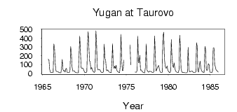
(Units: m3/s)
| ID | Year | Jan | Feb | Mar | Apr | May | Jun | Jul | Aug | Sep | Oct | Nov | Dec |
|---|
| 6877 | 1965 | | | | | | | | | 161.00 | 152.00 | 45.90 | 11.90 |
| 6877 | 1966 | 10.50 | 8.39 | 7.84 | 13.20 | 335.00 | 293.00 | 94.40 | 28.00 | 22.60 | 19.50 | 19.20 | 12.20 |
| 6877 | 1967 | 8.28 | 6.91 | 6.94 | 66.50 | 160.00 | 45.30 | 28.00 | 33.10 | 14.80 | 51.10 | 58.70 | 12.90 |
| 6877 | 1968 | 9.26 | 8.44 | 8.18 | 35.10 | 304.00 | 239.00 | 82.00 | 28.00 | 29.20 | 30.40 | 19.10 | 10.40 |
| 6877 | 1969 | 7.76 | 6.62 | 6.11 | 7.57 | 217.00 | 425.00 | 256.00 | 68.10 | 57.10 | 62.90 | 50.80 | 31.80 |
| 6877 | 1970 | 13.10 | 9.67 | 8.91 | 19.10 | 320.00 | 475.00 | 309.00 | 143.00 | 130.00 | 45.90 | 66.20 | 39.90 |
| 6877 | 1971 | 24.10 | 15.30 | 11.00 | 25.00 | 484.00 | 348.00 | 67.50 | 39.90 | 40.60 | 44.20 | 41.10 | 19.20 |
| 6877 | 1972 | 10.40 | 8.74 | 8.58 | 22.50 | 333.00 | 167.00 | 150.00 | 39.50 | 30.40 | 41.80 | 27.00 | 16.30 |
| 6877 | 1973 | 11.60 | 9.00 | 8.16 | 116.00 | 336.00 | 101.00 | 55.90 | 82.10 | 54.10 | 91.90 | 34.60 | 23.50 |
| 6877 | 1974 | 15.30 | 8.22 | 8.27 | 95.90 | 443.00 | 175.00 | 32.10 | 34.00 | 152.00 | | | |
| 6877 | 1975 | | | | | | 323.00 | 96.30 | | | | | |
| 6877 | 1976 | 14.80 | 14.10 | 12.40 | 31.80 | 425.00 | 120.00 | 127.00 | 205.00 | 36.80 | 39.80 | 23.40 | 17.20 |
| 6877 | 1977 | 10.30 | 7.60 | 6.44 | 85.20 | 334.00 | 41.20 | 26.90 | 14.80 | 15.80 | 24.60 | 22.30 | 21.70 |
| 6877 | 1978 | 15.10 | 12.60 | 10.90 | 15.70 | 427.00 | 215.00 | 28.60 | 38.90 | 63.60 | 78.70 | 90.00 | 38.60 |
| 6877 | 1979 | 16.30 | 11.20 | 11.00 | 12.90 | 417.00 | 468.00 | 181.00 | 90.00 | 60.50 | 60.60 | 84.80 | 39.80 |
| 6877 | 1980 | 19.50 | 11.90 | 8.34 | 26.60 | 387.00 | 193.00 | 82.80 | 66.50 | 119.00 | 59.10 | 31.30 | 18.50 |
| 6877 | 1981 | 14.20 | 9.34 | 9.34 | 42.30 | 433.00 | 310.00 | 51.00 | 15.80 | 10.40 | 11.80 | 7.99 | 7.93 |
| 6877 | 1982 | 7.16 | 6.36 | 6.75 | 15.30 | 296.00 | 70.40 | 18.80 | 15.90 | 23.00 | 23.10 | 24.90 | 15.00 |
| 6877 | 1983 | 13.00 | 10.60 | 10.20 | 17.80 | 348.00 | 308.00 | 24.70 | 15.00 | 63.40 | 140.00 | 73.50 | 33.80 |
| 6877 | 1984 | 22.20 | 16.10 | 10.40 | 11.00 | 306.00 | 273.00 | 46.20 | 31.70 | 48.10 | 109.00 | 99.00 | 17.30 |
| 6877 | 1985 | 10.50 | 9.71 | 8.44 | 27.10 | 287.00 | 288.00 | 94.00 | 75.20 | 38.70 | 33.10 | 25.20 | 14.70 |
 Return to R-Arctic Net Home Page