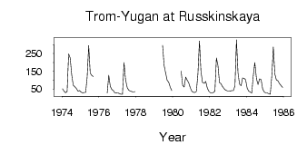
| PointID: | 6871 | Code: | 10497 | Latitude (decimal degrees): | 62.15 | Longitude (decimal degrees): | 73.60 | Drainage Area (km2): | 8800.00 | Source: | SHI | Hydrological Zone: | Ob | Name: | Trom-Yugan at Russkinskaya |
|---|
| Download | |
|---|---|
| Site Descriptor Information | Site Time Series Data |
| Link to all available data | |
| ID | Year | Jan | Feb | Mar | Apr | May | Jun | Jul | Aug | Sep | Oct | Nov | Dec |
|---|---|---|---|---|---|---|---|---|---|---|---|---|---|
| 6871 | 1974 | 51.10 | 37.60 | 29.00 | 34.80 | 247.00 | 226.00 | 131.00 | 72.10 | 63.10 | 51.50 | 37.60 | 40.70 |
| 6871 | 1975 | 32.00 | 27.70 | 29.40 | 30.20 | 117.00 | 296.00 | 139.00 | 127.00 | 119.00 | |||
| 6871 | 1976 | 27.70 | 127.00 | 63.70 | 47.30 | 41.10 | 27.50 | 28.60 | |||||
| 6871 | 1977 | 27.50 | 23.40 | 20.50 | 19.50 | 200.00 | 104.00 | 56.60 | 41.50 | 38.90 | 34.40 | 32.90 | 34.40 |
| 6871 | 1979 | 297.00 | 182.00 | 141.00 | 98.20 | 87.40 | 60.90 | 40.90 | |||||
| 6871 | 1980 | 152.00 | 70.30 | 60.70 | 117.00 | 100.00 | 84.20 | 56.60 | |||||
| 6871 | 1981 | 37.10 | 30.40 | 29.40 | 36.00 | 133.00 | 321.00 | 149.00 | 87.00 | 80.90 | 92.70 | 55.30 | 37.70 |
| 6871 | 1982 | 28.50 | 27.20 | 29.40 | 37.70 | 226.00 | 182.00 | 86.90 | 79.50 | 63.10 | 51.80 | 43.10 | 39.50 |
| 6871 | 1983 | 39.70 | 38.60 | 40.20 | 40.80 | 67.60 | 328.00 | 141.00 | 76.70 | 68.30 | 112.00 | 110.00 | 101.00 |
| 6871 | 1984 | 54.70 | 36.70 | 33.70 | 26.40 | 125.00 | 199.00 | 105.00 | 75.30 | 107.00 | 102.00 | 50.50 | 34.00 |
| 6871 | 1985 | 27.50 | 26.90 | 22.10 | 20.30 | 123.00 | 287.00 | 134.00 | 101.00 | 96.30 | 80.70 | 67.70 | 58.10 |
 Return to R-Arctic Net Home Page