Trom-Yugan at Kochevije
Ob
| PointID: | 6870 |
Code: | 10496 |
Latitude (decimal degrees): | 62.38 |
Longitude (decimal degrees): | 73.08 |
Drainage Area (km2): | 5860.00 |
Source: | SHI |
Hydrological Zone: | Ob |
Name: | Trom-Yugan at Kochevije |
Field Definitions
Site Time Series Plot:
Site Data File:
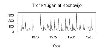
(Units: m3/s)
| ID | Year | Jan | Feb | Mar | Apr | May | Jun | Jul | Aug | Sep | Oct | Nov | Dec |
|---|
| 6870 | 1966 | 20.20 | 16.30 | 17.10 | 17.10 | 63.80 | 277.00 | 81.60 | 52.70 | 71.10 | 87.60 | 50.60 | 32.20 |
| 6870 | 1967 | 18.00 | 17.80 | 16.80 | 35.40 | 168.00 | 56.20 | 34.00 | 25.60 | 29.60 | 46.50 | 43.20 | 27.50 |
| 6870 | 1968 | 22.20 | 18.40 | 15.10 | 18.10 | 87.60 | 53.70 | 43.00 | 35.70 | 40.50 | | | 15.10 |
| 6870 | 1969 | 12.50 | 10.30 | 10.70 | 10.60 | 20.80 | 190.00 | 66.80 | | | | | |
| 6870 | 1971 | | | | | 102.00 | 316.00 | 127.00 | 47.90 | 50.40 | 73.10 | 55.20 | 35.20 |
| 6870 | 1972 | 19.70 | 15.60 | 10.10 | 10.90 | 75.40 | 195.00 | 57.60 | 69.20 | 74.10 | 75.20 | 44.90 | 28.40 |
| 6870 | 1973 | 21.60 | 18.50 | 16.70 | 21.30 | 144.00 | 103.00 | 57.40 | 53.20 | 82.00 | 112.00 | 51.70 | 42.30 |
| 6870 | 1974 | 28.20 | 21.20 | 21.60 | 21.40 | 219.00 | 178.00 | 76.40 | 41.70 | 42.50 | 40.00 | 23.40 | 19.60 |
| 6870 | 1975 | 16.40 | 15.00 | 14.10 | 16.30 | 91.20 | 240.00 | 83.50 | 92.20 | 79.00 | 79.10 | 47.00 | 35.50 |
| 6870 | 1976 | 25.10 | 20.40 | 17.90 | 20.50 | 261.00 | 209.00 | 76.50 | 36.90 | 27.50 | 23.50 | 16.90 | 16.90 |
| 6870 | 1977 | 15.50 | 12.90 | 12.40 | 13.70 | 146.00 | 58.90 | 32.30 | 24.40 | 22.80 | 19.40 | 20.50 | 17.70 |
| 6870 | 1978 | 14.10 | 13.30 | 10.30 | 9.56 | 28.90 | 239.00 | 69.20 | 60.60 | 88.90 | 145.00 | 87.50 | 51.50 |
| 6870 | 1979 | 30.40 | 22.40 | 19.40 | 20.80 | 265.00 | 235.00 | 121.00 | 98.80 | 67.30 | 55.40 | 38.80 | 26.80 |
| 6870 | 1980 | 25.50 | 22.10 | 17.30 | 20.00 | 160.00 | 106.00 | 45.80 | 40.00 | 98.40 | 69.20 | 42.20 | 29.50 |
| 6870 | 1981 | 23.70 | 22.90 | 18.00 | 18.80 | 98.40 | 335.00 | 93.40 | 57.50 | 56.50 | 61.50 | 37.00 | 33.40 |
| 6870 | 1982 | 31.30 | 28.90 | 28.00 | 32.30 | 173.00 | 144.00 | 59.30 | 60.60 | 52.90 | | | |
| 6870 | 1983 | | | | | 41.00 | 271.00 | 85.20 | 38.50 | 35.80 | 72.60 | | |
| 6870 | 1984 | | | | | | | 77.50 | 53.00 | 83.20 | 83.80 | 57.40 | 33.70 |
| 6870 | 1985 | 17.70 | 11.40 | 11.70 | 12.30 | 85.20 | 235.00 | 77.60 | 66.80 | 67.60 | 57.40 | 37.20 | 24.70 |
 Return to R-Arctic Net Home Page