Muza at Kopanoje Ozero
Ob
| PointID: | 6848 |
Code: | 10447 |
Latitude (decimal degrees): | 57.53 |
Longitude (decimal degrees): | 82.90 |
Drainage Area (km2): | 214.00 |
Source: | SHI |
Hydrological Zone: | Ob |
Name: | Muza at Kopanoje Ozero |
Field Definitions
Site Time Series Plot:
Site Data File:
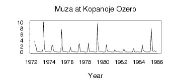
(Units: m3/s)
| ID | Year | Jan | Feb | Mar | Apr | May | Jun | Jul | Aug | Sep | Oct | Nov | Dec |
|---|
| 6848 | 1972 | | | | | 3.65 | 2.31 | 1.77 | 0.12 | 0.16 | 0.24 | 0.16 | 0.07 |
| 6848 | 1973 | 0.04 | 0.09 | 0.08 | 0.84 | 10.20 | 1.40 | 0.30 | 0.12 | 0.10 | 0.12 | 0.13 | 0.12 |
| 6848 | 1974 | 0.08 | 0.06 | 0.05 | 2.10 | 2.29 | 0.86 | 0.14 | 0.10 | 0.10 | 0.09 | 0.04 | 0.03 |
| 6848 | 1975 | 0.02 | 0.04 | 0.03 | 0.05 | 7.64 | 2.08 | 0.17 | 0.10 | 0.11 | 0.11 | 0.06 | 0.06 |
| 6848 | 1976 | 0.04 | 0.05 | 0.05 | 0.43 | 1.64 | 0.38 | 0.21 | 0.09 | 0.11 | 0.12 | 0.06 | 0.04 |
| 6848 | 1977 | 0.03 | 0.02 | 0.02 | 2.32 | 2.85 | 0.19 | 0.13 | 0.12 | 0.16 | 0.14 | 0.08 | 0.05 |
| 6848 | 1978 | 0.05 | 0.05 | 0.05 | 0.56 | 3.04 | 0.39 | 0.11 | 0.13 | 0.13 | 0.15 | 0.10 | 0.07 |
| 6848 | 1979 | 0.05 | 0.04 | 0.04 | 0.06 | 9.59 | 1.92 | 0.18 | 0.11 | 0.08 | 0.09 | 0.07 | 0.06 |
| 6848 | 1980 | 0.05 | 0.04 | 0.03 | 0.22 | 2.46 | 0.64 | 0.16 | 0.12 | 0.07 | 0.09 | 0.07 | 0.05 |
| 6848 | 1981 | 0.04 | 0.03 | 0.03 | 0.75 | 0.44 | 0.21 | 0.07 | 0.06 | 0.06 | 0.07 | 0.05 | 0.04 |
| 6848 | 1982 | 0.03 | 0.03 | 0.04 | 0.88 | 0.78 | 0.12 | 0.05 | 0.06 | 0.04 | 0.03 | 0.03 | 0.03 |
| 6848 | 1983 | 0.03 | 0.02 | 0.02 | 0.04 | 1.20 | 0.59 | 0.04 | 0.04 | 0.05 | 0.07 | 0.06 | 0.05 |
| 6848 | 1984 | 0.04 | 0.02 | 0.03 | 0.04 | 2.45 | 0.70 | 0.49 | 0.09 | 0.07 | 0.09 | 0.05 | 0.05 |
| 6848 | 1985 | 0.06 | 0.05 | 0.06 | 0.61 | 8.09 | 3.61 | 0.33 | 0.29 | 0.38 | 0.36 | 0.15 | 0.08 |
 Return to R-Arctic Net Home Page