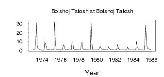
| PointID: | 6837 | Code: | 10426 | Latitude (decimal degrees): | 57.45 | Longitude (decimal degrees): | 83.40 | Drainage Area (km2): | 1095.00 | Source: | SHI | Hydrological Zone: | Ob | Name: | Bolshoj Tatosh at Bolshoj Tatosh |
|---|
| Download | |
|---|---|
| Site Descriptor Information | Site Time Series Data |
| Link to all available data | |
| ID | Year | Jan | Feb | Mar | Apr | May | Jun | Jul | Aug | Sep | Oct | Nov | Dec |
|---|---|---|---|---|---|---|---|---|---|---|---|---|---|
| 6837 | 1973 | 1.06 | 0.87 | 0.87 | 8.36 | 31.00 | 5.99 | 1.98 | 1.60 | 0.85 | 0.77 | 0.52 | 0.46 |
| 6837 | 1974 | 0.47 | 0.38 | 0.42 | 9.88 | 6.99 | 4.64 | 1.12 | 0.98 | 1.02 | 0.97 | 0.86 | 0.77 |
| 6837 | 1975 | 0.89 | 0.87 | 0.85 | 1.11 | 31.80 | 9.11 | 1.33 | 0.99 | 0.90 | 0.95 | 0.89 | 0.85 |
| 6837 | 1976 | 0.88 | 0.79 | 0.80 | 3.99 | 6.73 | 2.60 | 1.37 | 0.98 | 0.99 | 1.17 | 0.93 | 0.81 |
| 6837 | 1977 | 0.63 | 0.74 | 0.77 | 9.81 | 9.06 | 1.66 | 1.18 | 1.17 | 1.16 | 1.03 | 0.90 | 0.87 |
| 6837 | 1978 | 0.76 | 0.79 | 0.86 | 4.55 | 9.41 | 2.59 | 1.33 | 0.95 | 0.90 | 0.97 | 0.91 | 0.81 |
| 6837 | 1979 | 0.67 | 0.55 | 0.58 | 0.93 | 32.80 | 9.88 | 1.15 | 0.72 | 0.74 | 0.82 | 0.76 | 0.75 |
| 6837 | 1980 | 0.67 | 0.57 | 0.49 | 2.51 | 4.65 | 2.42 | 1.43 | 1.47 | 1.32 | 1.30 | 0.98 | 0.90 |
| 6837 | 1981 | 0.86 | 0.76 | 0.80 | 4.22 | 2.23 | 1.47 | 0.92 | 0.89 | 0.89 | 0.86 | 0.70 | 0.70 |
| 6837 | 1982 | 0.70 | 0.62 | 0.65 | 6.59 | 2.56 | 1.22 | 0.91 | 0.78 | 0.78 | 0.77 | 0.67 | 0.60 |
| 6837 | 1983 | 0.48 | 0.42 | 0.48 | 0.65 | 3.55 | 2.16 | 0.66 | 0.61 | 0.70 | 0.65 | 0.63 | 0.58 |
| 6837 | 1984 | 0.56 | 0.46 | 0.50 | 0.57 | 9.90 | 3.21 | 2.23 | 1.08 | 0.87 | 0.80 | 0.70 | 0.61 |
| 6837 | 1985 | 0.57 | 0.37 | 0.38 | 7.50 | 28.30 | 13.80 | 2.90 | 1.92 | 1.80 | 1.50 | 1.32 | 0.95 |
 Return to R-Arctic Net Home Page