Itatka at Tihomirovka
Ob
| PointID: | 6832 |
Code: | 10420 |
Latitude (decimal degrees): | 56.85 |
Longitude (decimal degrees): | 86.07 |
Drainage Area (km2): | 320.00 |
Source: | SHI |
Hydrological Zone: | Ob |
Name: | Itatka at Tihomirovka |
Field Definitions
Site Time Series Plot:
Site Data File:
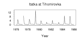
(Units: m3/s)
| ID | Year | Jan | Feb | Mar | Apr | May | Jun | Jul | Aug | Sep | Oct | Nov | Dec |
|---|
| 6832 | 1976 | 0.42 | 0.40 | 0.34 | 5.11 | 3.54 | 0.68 | 0.58 | 0.49 | 0.39 | 0.45 | 0.38 | 0.29 |
| 6832 | 1977 | 0.21 | 3.0e-03 | | 8.70 | 2.81 | 0.57 | 0.52 | 0.45 | 0.34 | 0.41 | 0.37 | 0.27 |
| 6832 | 1978 | 0.36 | 0.31 | 0.31 | 5.46 | 3.87 | 1.00 | 0.66 | 0.57 | 0.58 | 0.58 | 0.51 | 0.50 |
| 6832 | 1979 | 0.36 | 0.30 | 0.35 | 3.59 | 14.00 | 1.15 | 0.53 | 0.53 | 0.59 | 0.56 | 0.47 | 0.47 |
| 6832 | 1980 | 0.36 | 0.18 | 0.17 | 3.93 | 3.21 | 0.80 | 0.60 | 0.51 | 0.36 | 0.38 | 0.45 | 0.43 |
| 6832 | 1981 | 0.43 | 0.35 | 0.53 | 2.50 | 0.97 | 0.71 | 0.62 | 0.76 | 0.70 | 0.64 | 0.37 | 0.25 |
| 6832 | 1982 | 0.34 | 0.45 | 0.64 | 4.31 | 1.18 | 0.65 | 0.63 | 0.68 | 0.68 | 0.73 | 0.70 | 0.66 |
| 6832 | 1983 | 0.56 | 0.43 | 0.39 | 0.52 | 2.38 | 0.74 | 0.43 | 0.37 | 0.43 | 0.38 | 0.35 | 0.37 |
| 6832 | 1984 | 0.23 | 0.22 | 0.48 | 1.63 | 8.67 | 1.48 | 0.72 | 0.77 | 0.79 | 0.66 | 0.71 | 0.36 |
| 6832 | 1985 | 0.28 | 0.28 | 0.22 | 8.13 | 8.05 | 1.42 | 0.49 | 0.45 | 0.37 | 0.40 | 0.29 | 0.28 |
 Return to R-Arctic Net Home Page