Kiya at Okunejevo
Ob
| PointID: | 6817 |
Code: | 10388 |
Latitude (decimal degrees): | 56.77 |
Longitude (decimal degrees): | 86.97 |
Drainage Area (km2): | 14900.00 |
Source: | SHI |
Hydrological Zone: | Ob |
Name: | Kiya at Okunejevo |
Field Definitions
Site Time Series Plot:
Site Data File:
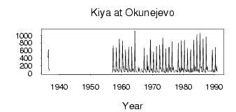
(Units: m3/s)
| ID | Year | Jan | Feb | Mar | Apr | May | Jun | Jul | Aug | Sep | Oct | Nov | Dec |
|---|
| 6817 | 1936 | | | | | 418.00 | 622.00 | 125.00 | 116.00 | 111.00 | 73.90 | | |
| 6817 | 1957 | 29.20 | 27.50 | 26.30 | 229.00 | 722.00 | 478.00 | 150.00 | 83.50 | 94.70 | 76.50 | 79.30 | 47.00 |
| 6817 | 1958 | 36.00 | 32.00 | 31.40 | 157.00 | 674.00 | 599.00 | 119.00 | 109.00 | 71.20 | 99.30 | 73.30 | 44.80 |
| 6817 | 1959 | 37.60 | 28.10 | 28.60 | 122.00 | 901.00 | 624.00 | 172.00 | 97.90 | 95.60 | 89.20 | 67.00 | 46.80 |
| 6817 | 1960 | 31.00 | 25.60 | 25.50 | 151.00 | 854.00 | 649.00 | 230.00 | 140.00 | 180.00 | 112.00 | 79.80 | 43.40 |
| 6817 | 1961 | 36.70 | 34.50 | 34.30 | 501.00 | 622.00 | 215.00 | 116.00 | 87.60 | 102.00 | 122.00 | 71.90 | 48.40 |
| 6817 | 1962 | 32.50 | 26.90 | 35.10 | 264.00 | 689.00 | 264.00 | 169.00 | 104.00 | 54.80 | 110.00 | 67.30 | 40.10 |
| 6817 | 1963 | 39.90 | 34.20 | 31.20 | 66.40 | 698.00 | 311.00 | 64.20 | 62.00 | 108.00 | 119.00 | 94.90 | 90.70 |
| 6817 | 1964 | 85.20 | 42.10 | 29.70 | 32.20 | 1120.00 | 568.00 | 121.00 | 66.20 | 47.40 | 45.80 | 47.20 | 44.70 |
| 6817 | 1965 | 33.10 | 25.80 | 25.90 | | | 172.00 | 64.60 | 41.20 | 139.00 | 101.00 | 71.40 | 70.70 |
| 6817 | 1966 | 50.10 | 27.40 | 23.30 | | | | 114.00 | 64.80 | 38.70 | 46.10 | 46.10 | 40.80 |
| 6817 | 1967 | 27.50 | 23.30 | 24.10 | 209.00 | 661.00 | 138.00 | 123.00 | 85.70 | 106.00 | 97.70 | 69.40 | 33.70 |
| 6817 | 1968 | 26.00 | 22.30 | 41.20 | 170.00 | 477.00 | 126.00 | 83.90 | 189.00 | 104.00 | 84.80 | 94.80 | 48.50 |
| 6817 | 1969 | 35.60 | 25.20 | 25.80 | 78.70 | 885.00 | 861.00 | 127.00 | 82.00 | 79.50 | 109.00 | 112.00 | 59.30 |
| 6817 | 1970 | 23.60 | 19.70 | 16.30 | 299.00 | 565.00 | 368.00 | 94.80 | 85.40 | 44.90 | 56.70 | 50.80 | 34.80 |
| 6817 | 1971 | 27.80 | 21.80 | 18.80 | 241.00 | 708.00 | 227.00 | 115.00 | 38.00 | 31.80 | 27.20 | 34.90 | 36.50 |
| 6817 | 1972 | 24.00 | 22.50 | 21.80 | 227.00 | 740.00 | 544.00 | 233.00 | 123.00 | 152.00 | 120.00 | 105.00 | 60.20 |
| 6817 | 1973 | 38.30 | 38.60 | 37.00 | 311.00 | 933.00 | 690.00 | 145.00 | 91.20 | 30.40 | 34.30 | 40.00 | 39.40 |
| 6817 | 1974 | 24.50 | 14.40 | 9.75 | 233.00 | 645.00 | 226.00 | 68.60 | 44.20 | 59.10 | 149.00 | 62.50 | 30.90 |
| 6817 | 1975 | 24.80 | 27.00 | 30.60 | 161.00 | 682.00 | 686.00 | 116.00 | 61.80 | 110.00 | 145.00 | 162.00 | 73.90 |
| 6817 | 1976 | 44.70 | 29.10 | 26.70 | 102.00 | 833.00 | 264.00 | 91.00 | 89.90 | 112.00 | 168.00 | 114.00 | 54.00 |
| 6817 | 1977 | 35.20 | 22.90 | 24.20 | | | | 56.20 | 52.70 | 86.60 | 62.80 | 59.80 | 39.70 |
| 6817 | 1978 | 29.50 | 27.70 | 28.40 | 189.00 | 795.00 | 340.00 | 113.00 | 104.00 | 96.80 | 16.00 | 148.00 | 98.20 |
| 6817 | 1979 | 65.00 | 31.00 | 32.60 | 77.50 | 856.00 | 532.00 | 88.00 | 71.20 | 96.70 | 130.00 | 118.00 | 54.10 |
| 6817 | 1980 | 36.90 | 26.90 | 24.20 | 169.00 | 874.00 | 256.00 | 107.00 | 92.50 | 54.40 | 51.90 | 74.70 | 74.20 |
| 6817 | 1981 | 40.00 | 34.40 | 34.70 | 303.00 | 662.00 | 143.00 | 50.30 | 49.60 | 46.60 | 91.00 | 46.60 | 36.10 |
| 6817 | 1982 | 29.40 | 24.30 | 25.70 | 399.00 | 621.00 | 85.00 | 40.50 | 27.10 | 23.10 | 125.00 | 85.40 | 51.70 |
| 6817 | 1983 | 39.20 | 41.70 | 38.00 | 77.10 | 878.00 | 553.00 | 106.00 | 51.60 | 55.20 | 166.00 | 175.00 | 126.00 |
| 6817 | 1984 | 72.30 | 51.60 | 57.70 | 79.50 | 1020.00 | 592.00 | 146.00 | 58.50 | 49.00 | 85.60 | 109.00 | 50.80 |
| 6817 | 1985 | 32.30 | 24.30 | 18.30 | 307.00 | 1050.00 | 703.00 | 175.00 | 166.00 | 128.00 | 143.00 | 173.00 | 46.90 |
| 6817 | 1986 | 43.30 | 38.60 | 31.90 | 164.00 | 903.00 | 649.00 | 103.00 | 82.20 | 87.00 | 94.40 | 57.10 | 31.10 |
| 6817 | 1987 | 23.80 | 25.80 | 18.90 | 99.40 | 961.00 | 387.00 | 119.00 | 89.60 | 131.00 | 169.00 | 60.40 | 48.90 |
| 6817 | 1989 | 51.70 | 42.80 | 40.30 | 305.00 | 613.00 | 468.00 | 76.90 | 43.10 | 25.10 | 37.80 | 108.00 | 47.00 |
| 6817 | 1990 | 41.40 | 34.30 | 30.00 | 148.00 | 680.00 | 162.00 | 77.50 | 83.50 | 71.60 | 175.00 | 58.80 | 44.20 |
| Other Close Sites |
|---|
| PointID |
Latitude |
Longitude | Drainage Area | Source |
Name |
|---|
| 6792 | 56.85 | 86.62 | 92500.00 | SHI | Chulim at Ziryanskoje |
 Return to R-Arctic Net Home Page