Kiya at Chumaj
Ob
| PointID: | 6815 |
Code: | 10385 |
Latitude (decimal degrees): | 55.70 |
Longitude (decimal degrees): | 87.80 |
Drainage Area (km2): | 5680.00 |
Source: | SHI |
Hydrological Zone: | Ob |
Name: | Kiya at Chumaj |
Field Definitions
Site Time Series Plot:
Site Data File:
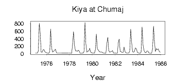
(Units: m3/s)
| ID | Year | Jan | Feb | Mar | Apr | May | Jun | Jul | Aug | Sep | Oct | Nov | Dec |
|---|
| 6815 | 1975 | 11.80 | 13.60 | 12.50 | 68.70 | 802.00 | 531.00 | 43.50 | 36.50 | 106.00 | 109.00 | 45.50 | 31.60 |
| 6815 | 1976 | 20.00 | 13.40 | 11.50 | 57.70 | 653.00 | 143.00 | 42.00 | 61.70 | 84.00 | 117.00 | 26.40 | 17.20 |
| 6815 | 1978 | 21.30 | 12.70 | 10.10 | 258.00 | 584.00 | 221.00 | 74.90 | 77.10 | 61.60 | 91.20 | 64.80 | 9.40 |
| 6815 | 1979 | 11.30 | 16.30 | 12.40 | 53.40 | 827.00 | 271.00 | 38.80 | 68.00 | 67.40 | 143.00 | 43.30 | 23.80 |
| 6815 | 1980 | 20.70 | 16.10 | 12.60 | 120.00 | 518.00 | 130.00 | 95.10 | 58.30 | 43.80 | 46.30 | 41.00 | 21.40 |
| 6815 | 1981 | 16.50 | 10.50 | 9.86 | 274.00 | 434.00 | 84.40 | 40.30 | 51.70 | 57.60 | 83.40 | 16.90 | 13.00 |
| 6815 | 1982 | 16.20 | 10.30 | 9.03 | 303.00 | 386.00 | 55.00 | 54.50 | 30.90 | 30.80 | 175.00 | 63.20 | 26.30 |
| 6815 | 1983 | 16.40 | 14.90 | 12.80 | 66.30 | 650.00 | 322.00 | 52.60 | 39.50 | 59.20 | 154.00 | 130.00 | 31.30 |
| 6815 | 1984 | 22.40 | 14.00 | 11.20 | 39.80 | 710.00 | 224.00 | 82.40 | 36.80 | 22.70 | 71.60 | 73.20 | 23.60 |
| 6815 | 1985 | 14.30 | 10.60 | 10.80 | 128.00 | 731.00 | 330.00 | 57.60 | 135.00 | 100.00 | 128.00 | 59.50 | 34.90 |
 Return to R-Arctic Net Home Page