Poros at Zorkaltsevo
Ob
| PointID: | 6784 |
Code: | 10305 |
Latitude (decimal degrees): | 56.53 |
Longitude (decimal degrees): | 84.73 |
Drainage Area (km2): | 316.00 |
Source: | SHI |
Hydrological Zone: | Ob |
Name: | Poros at Zorkaltsevo |
Field Definitions
Site Time Series Plot:
Site Data File:
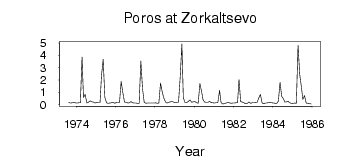
(Units: m3/s)
| ID | Year | Jan | Feb | Mar | Apr | May | Jun | Jul | Aug | Sep | Oct | Nov | Dec |
|---|
| 6784 | 1973 | | | | | | | | 0.17 | 0.13 | 0.14 | 0.16 | 0.14 |
| 6784 | 1974 | 0.12 | 0.14 | 0.15 | 3.87 | 0.58 | 0.82 | 0.12 | 0.20 | 0.30 | 0.23 | 0.20 | 0.13 |
| 6784 | 1975 | 0.19 | 0.16 | 0.16 | 2.35 | 3.68 | 0.59 | 0.14 | 0.10 | 0.12 | 0.14 | 0.19 | 0.11 |
| 6784 | 1976 | 0.16 | 0.14 | 0.15 | 1.88 | 0.96 | 0.21 | 0.19 | 0.13 | 0.15 | 0.24 | 0.14 | 0.13 |
| 6784 | 1977 | 0.12 | 0.09 | 0.11 | 3.54 | 1.29 | 0.18 | 0.10 | 0.12 | 0.13 | 0.13 | 0.13 | 0.13 |
| 6784 | 1978 | 0.14 | 0.10 | 0.13 | 1.74 | 1.04 | 0.51 | 0.21 | 0.13 | 0.18 | 0.22 | 0.24 | 0.20 |
| 6784 | 1979 | 0.14 | 0.18 | 0.19 | 2.24 | 4.93 | 0.56 | 0.17 | 0.18 | 0.25 | 0.38 | 0.18 | 0.22 |
| 6784 | 1980 | 0.25 | 0.16 | 0.11 | 1.71 | 1.08 | 0.39 | 0.20 | 0.18 | 0.19 | 0.27 | 0.16 | 0.14 |
| 6784 | 1981 | 0.13 | 0.16 | 0.19 | 1.15 | 0.19 | 0.04 | 0.09 | 0.12 | 0.16 | 0.15 | 0.11 | 0.12 |
| 6784 | 1982 | 0.13 | 0.14 | 0.16 | 2.04 | 0.25 | 0.20 | 0.14 | 0.07 | 0.10 | 0.20 | 0.10 | 0.14 |
| 6784 | 1983 | 0.15 | 0.18 | 0.16 | 0.52 | 0.83 | 0.15 | 0.06 | 0.13 | 0.12 | 0.17 | 0.18 | 0.14 |
| 6784 | 1984 | 0.13 | 0.11 | 0.09 | 0.29 | 1.80 | 0.66 | 0.48 | 0.21 | 0.22 | 0.26 | 0.14 | 0.08 |
| 6784 | 1985 | 0.11 | 0.12 | 0.11 | 4.82 | 2.45 | 1.44 | 0.42 | 0.73 | 0.12 | 0.10 | 0.08 | 0.04 |
 Return to R-Arctic Net Home Page