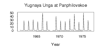
| PointID: | 6780 | Code: | 10295 | Latitude (decimal degrees): | 54.95 | Longitude (decimal degrees): | 86.38 | Drainage Area (km2): | 978.00 | Source: | SHI | Hydrological Zone: | Ob | Name: | Yugnaya Unga at Panphilovskoe |
|---|
| Download | |
|---|---|
| Site Descriptor Information | Site Time Series Data |
| Link to all available data | |
| ID | Year | Jan | Feb | Mar | Apr | May | Jun | Jul | Aug | Sep | Oct | Nov | Dec |
|---|---|---|---|---|---|---|---|---|---|---|---|---|---|
| 6780 | 1961 | 1.52 | 0.67 | 0.56 | 0.59 | 0.55 | 0.59 | 0.67 | |||||
| 6780 | 1962 | 0.79 | 0.70 | 1.46 | 28.20 | 2.53 | 1.40 | 0.44 | 0.27 | 0.37 | 0.81 | 0.46 | 0.48 |
| 6780 | 1963 | 0.51 | 0.35 | 0.67 | 28.10 | 13.70 | 1.11 | 0.85 | 0.58 | 0.97 | 1.26 | 1.85 | 0.94 |
| 6780 | 1964 | 0.70 | 0.39 | 0.40 | 31.20 | 9.79 | 1.85 | 0.94 | 0.58 | 0.47 | 0.74 | 0.65 | 0.43 |
| 6780 | 1965 | 0.60 | 0.59 | 4.50 | 25.70 | 7.44 | 0.56 | 0.34 | 0.38 | 0.70 | 0.75 | 0.33 | 0.52 |
| 6780 | 1966 | 0.43 | 0.33 | 0.42 | 34.00 | 49.60 | 2.25 | 0.80 | 0.51 | 0.49 | 0.68 | 0.58 | 0.37 |
| 6780 | 1967 | 0.36 | 0.45 | 0.54 | 27.30 | 8.44 | 1.81 | 1.82 | 0.90 | 0.83 | 1.20 | 0.59 | 0.34 |
| 6780 | 1968 | 0.60 | 0.52 | 0.73 | 0.63 | 0.33 | 0.28 | ||||||
| 6780 | 1969 | 0.20 | 0.18 | 0.21 | 41.00 | 14.50 | 1.93 | 0.39 | 0.41 | 0.44 | 0.60 | 0.67 | 0.20 |
| 6780 | 1970 | 0.27 | 0.31 | 0.26 | 27.80 | 2.11 | 0.93 | 0.50 | 0.46 | 0.42 | 0.56 | 0.48 | 0.15 |
| 6780 | 1971 | 0.16 | 0.14 | 0.21 | 26.20 | 1.82 | 0.21 | 0.79 | 1.00 | 0.36 | 0.67 | 0.51 | 0.30 |
| 6780 | 1972 | 0.21 | 0.21 | 0.21 | 33.70 | 4.29 | 2.65 | 1.50 | 1.07 | 1.70 | 2.00 | 2.28 | 1.09 |
| 6780 | 1973 | 0.27 | 0.16 | 0.25 | 47.00 | 7.10 | 3.55 | 1.18 | 0.94 | 0.64 | 0.74 | 0.85 | 0.50 |
| 6780 | 1974 | 0.24 | 0.18 | 0.22 | 24.70 | 1.62 | 0.70 | 2.39 | 0.26 | 0.70 | 2.18 | 0.32 | 0.22 |
| 6780 | 1975 | 0.17 | 0.28 | 1.46 | 50.30 | 12.40 | 1.58 | 0.35 | 0.40 | 0.54 | 0.68 | 0.45 | 0.29 |
| 6780 | 1976 | 0.42 | 0.26 | 0.21 | 29.50 | 3.74 | 0.79 | 0.51 | 0.53 | 0.69 | 1.03 | 0.31 | 0.22 |
 Return to R-Arctic Net Home Page