Tom at Tomsk
Ob
| PointID: | 6763 |
Code: | 10252 |
Latitude (decimal degrees): | 56.50 |
Longitude (decimal degrees): | 84.92 |
Drainage Area (km2): | 57800.00 |
Source: | SHI |
Hydrological Zone: | Ob |
Name: | Tom at Tomsk |
Field Definitions
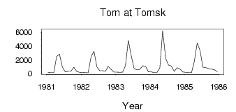
Site Time Series Plot:
Site Data File:
(Units: m3/s)
| ID | Year | Jan | Feb | Mar | Apr | May | Jun | Jul | Aug | Sep | Oct | Nov | Dec |
|---|
| 6763 | 1981 | 170.00 | 147.00 | 153.00 | 2480.00 | 2820.00 | 970.00 | 241.00 | 350.00 | 369.00 | 931.00 | 319.00 | 192.00 |
| 6763 | 1982 | 160.00 | 133.00 | 113.00 | 2490.00 | 3250.00 | 999.00 | 444.00 | 434.00 | 347.00 | 1050.00 | 619.00 | 221.00 |
| 6763 | 1983 | 225.00 | 195.00 | 212.00 | 1180.00 | 4830.00 | 2630.00 | 789.00 | 529.00 | 634.00 | 1140.00 | 1050.00 | 271.00 |
| 6763 | 1984 | 238.00 | 174.00 | 160.00 | 842.00 | 6230.00 | 2200.00 | 1250.00 | 1100.00 | 317.00 | 858.00 | 691.00 | 248.00 |
| 6763 | 1985 | 205.00 | 155.00 | 138.00 | 1810.00 | 4430.00 | 3370.00 | 936.00 | 877.00 | 721.00 | 658.00 | 564.00 | 296.00 |
| Other Close Sites |
|---|
| PointID |
Latitude |
Longitude | Drainage Area | Source |
Name |
|---|
| 6762 | 56.50 | 84.92 | 57000.00 | SHI | Tom at Tomsk |
 Return to R-Arctic Net Home Page