| PointID: | 676 | Code: | 07BK002 | Latitude (decimal degrees): | 55.27 | Longitude (decimal degrees): | -114.40 | Drainage Area (km2): | 14500.00 | Source: | Hydat | Hydrological Zone: | Mackenzie | Name: | LESSER SLAVE RIVER ABOVE OTAUWAU RIVER |
|---|
| Download | |
|---|---|
| Site Descriptor Information | Site Time Series Data |
| Link to all available data | |
| ID | Year | Jan | Feb | Mar | Apr | May | Jun | Jul | Aug | Sep | Oct | Nov | Dec |
|---|---|---|---|---|---|---|---|---|---|---|---|---|---|
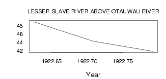
| 676 | 1922 | 48.90 | 44.30 | 41.90 |
| Other Close Sites | ||||||
|---|---|---|---|---|---|---|
| PointID | Latitude | Longitude | Drainage Area | Source | Name | |
| 677 | 55.26 | -114.31 | 15100.00 | Hydat | LESSER SLAVE RIVER AT SAULTEAUX LANDING | |
 Return to R-Arctic Net Home Page