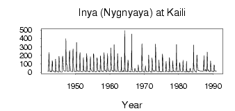
| PointID: | 6751 | Code: | 10219 | Latitude (decimal degrees): | 55.32 | Longitude (decimal degrees): | 84.10 | Drainage Area (km2): | 15700.00 | Source: | SHI | Hydrological Zone: | Ob | Name: | Inya (Nygnyaya) at Kaili |
|---|
| Download | |
|---|---|
| Site Descriptor Information | Site Time Series Data |
| Link to all available data | |
| ID | Year | Jan | Feb | Mar | Apr | May | Jun | Jul | Aug | Sep | Oct | Nov | Dec |
|---|---|---|---|---|---|---|---|---|---|---|---|---|---|
| 6751 | 1942 | 10.50 | 9.80 | 8.57 | 115.00 | 235.00 | 48.80 | 35.30 | 11.40 | 6.10 | 14.00 | 16.90 | 7.52 |
| 6751 | 1943 | 6.60 | 7.01 | 7.23 | 138.00 | 124.00 | 18.80 | 18.90 | 14.30 | 10.60 | 11.10 | 5.14 | 2.97 |
| 6751 | 1944 | 3.17 | 2.17 | 3.04 | 154.00 | 82.10 | 13.10 | 16.20 | 16.00 | 8.46 | 11.10 | 6.50 | 3.53 |
| 6751 | 1945 | 2.45 | 1.46 | 1.21 | 188.00 | 124.00 | 12.80 | 9.00 | 6.21 | 4.10 | 3.45 | 2.76 | 1.27 |
| 6751 | 1946 | 1.24 | 2.15 | 4.03 | 192.00 | 183.00 | 121.00 | 64.80 | 23.50 | 20.40 | 17.20 | 12.80 | 11.90 |
| 6751 | 1947 | 11.80 | 11.80 | 11.60 | 396.00 | 147.00 | 88.80 | 92.80 | 27.70 | 11.80 | 9.96 | 12.30 | 10.20 |
| 6751 | 1948 | 10.40 | 10.90 | 10.90 | 237.00 | 257.00 | 95.50 | 58.80 | 18.30 | 13.00 | 12.10 | 10.90 | 9.70 |
| 6751 | 1949 | 8.00 | 6.82 | 7.72 | 247.00 | 275.00 | 90.00 | 48.90 | 19.70 | 11.10 | 9.92 | 11.50 | 8.24 |
| 6751 | 1950 | 10.30 | 10.00 | 6.31 | 72.50 | 352.00 | 78.50 | 18.20 | 13.70 | 13.40 | 19.70 | 9.83 | 9.63 |
| 6751 | 1951 | 9.22 | 8.41 | 7.46 | 197.00 | 232.00 | 33.50 | 12.40 | 9.54 | 9.20 | 7.84 | 8.69 | 6.36 |
| 6751 | 1952 | 6.01 | 5.23 | 5.35 | 88.70 | 175.00 | 29.60 | 19.00 | 19.00 | 12.80 | 10.60 | 13.20 | 10.60 |
| 6751 | 1953 | 6.82 | 5.52 | 6.00 | 221.00 | 183.00 | 19.00 | 15.40 | 14.00 | 10.70 | 8.90 | 11.10 | 7.95 |
| 6751 | 1954 | 6.05 | 4.87 | 4.33 | 69.60 | 184.00 | 45.80 | 33.00 | 26.40 | 21.30 | 14.10 | 13.90 | 10.70 |
| 6751 | 1955 | 8.13 | 7.74 | 6.34 | 220.00 | 207.00 | 24.80 | 14.20 | 11.20 | 7.86 | 6.99 | 5.84 | 4.18 |
| 6751 | 1956 | 4.25 | 3.73 | 4.19 | 171.00 | 157.00 | 36.90 | 20.80 | 17.60 | 14.70 | 11.70 | 18.30 | 6.42 |
| 6751 | 1957 | 5.57 | 4.38 | 3.44 | 190.00 | 194.00 | 47.60 | 21.30 | 16.50 | 12.70 | 8.11 | 12.90 | 10.70 |
| 6751 | 1958 | 9.47 | 7.55 | 6.58 | 149.00 | 233.00 | 88.80 | 30.40 | 18.90 | 23.30 | 27.60 | 10.80 | 4.73 |
| 6751 | 1959 | 6.07 | 5.55 | 5.81 | 136.00 | 222.00 | 55.00 | 29.10 | 22.40 | 11.10 | 11.00 | 9.33 | 9.55 |
| 6751 | 1960 | 8.05 | 8.09 | 7.38 | 164.00 | 288.00 | 102.00 | 31.10 | 21.50 | 18.90 | 15.70 | 21.40 | 11.10 |
| 6751 | 1961 | 6.89 | 8.95 | 11.30 | 326.00 | 170.00 | 31.80 | 14.00 | 12.90 | 12.40 | 12.40 | 9.82 | 14.30 |
| 6751 | 1962 | 11.40 | 9.59 | 13.60 | 220.00 | 128.00 | 45.00 | 12.60 | 10.70 | 7.68 | 7.04 | 4.85 | 5.32 |
| 6751 | 1963 | 5.24 | 5.59 | 6.03 | 34.10 | 180.00 | 21.40 | 7.23 | 6.39 | 9.23 | 11.60 | 13.30 | 18.30 |
| 6751 | 1964 | 11.60 | 7.79 | 5.98 | 63.00 | 494.00 | 58.10 | 21.10 | 8.76 | 13.50 | 9.77 | 10.80 | 11.80 |
| 6751 | 1965 | 7.04 | 5.94 | 9.05 | 145.00 | 123.00 | 15.90 | 9.74 | 9.13 | 7.94 | 9.16 | 11.20 | 8.38 |
| 6751 | 1966 | 6.25 | 5.63 | 6.22 | 63.00 | 452.00 | 60.50 | 18.50 | 10.50 | 6.50 | 5.75 | 5.89 | 6.05 |
| 6751 | 1967 | 5.55 | 5.61 | 4.51 | 44.90 | 43.60 | 16.60 | 17.60 | 8.67 | 13.70 | 11.60 | 9.21 | 3.09 |
| 6751 | 1968 | 2.58 | 3.14 | 13.00 | 85.80 | 51.90 | 18.40 | 8.30 | 7.02 | 5.30 | 2.95 | 6.71 | 4.03 |
| 6751 | 1969 | 3.36 | 2.68 | 2.85 | 90.00 | 338.00 | 133.00 | 13.40 | 9.56 | 6.14 | 9.42 | 10.30 | 5.32 |
| 6751 | 1970 | 0.90 | 1.39 | 3.85 | 27.60 | 76.80 | 35.00 | 20.00 | 12.50 | 4.94 | 8.26 | 5.73 | 3.31 |
| 6751 | 1971 | 3.61 | 3.94 | 4.38 | 204.00 | 152.00 | 28.00 | 20.50 | 11.50 | 9.48 | 5.01 | 6.60 | 4.95 |
| 6751 | 1972 | 2.34 | 1.16 | 2.43 | 168.00 | 136.00 | 44.00 | 29.20 | 13.80 | 13.50 | 19.60 | 12.70 | 9.77 |
| 6751 | 1973 | 9.93 | 8.74 | 10.50 | 333.00 | 227.00 | 40.30 | 21.00 | 16.20 | 8.42 | 9.76 | 8.91 | 6.38 |
| 6751 | 1974 | 4.60 | 3.88 | 4.19 | 145.00 | 87.00 | 22.30 | 8.74 | 5.33 | 5.87 | 9.12 | 5.88 | 3.69 |
| 6751 | 1975 | 4.64 | 4.33 | 5.31 | 216.00 | 193.00 | 76.80 | 11.90 | 6.74 | 8.12 | |||
| 6751 | 1976 | 4.69 | 4.47 | 4.94 | 72.70 | 129.00 | 16.80 | 12.40 | 12.00 | 10.90 | 9.32 | 7.84 | 6.72 |
| 6751 | 1977 | 5.00 | 4.62 | 3.66 | 173.00 | 165.00 | 19.80 | 14.10 | 11.70 | 9.70 | 6.52 | 5.67 | 4.79 |
| 6751 | 1978 | 3.98 | 3.55 | 3.24 | 136.00 | 85.30 | 21.20 | 10.60 | 18.20 | 8.59 | 7.67 | 8.66 | 6.93 |
| 6751 | 1979 | 5.60 | 4.64 | 4.77 | 92.10 | 329.00 | 83.80 | 10.40 | 6.10 | 7.27 | 8.45 | 12.70 | 11.40 |
| 6751 | 1980 | 11.20 | 7.53 | 6.19 | 104.00 | 114.00 | 24.60 | 15.50 | 11.70 | 7.17 | 7.08 | 6.66 | 6.87 |
| 6751 | 1981 | 5.08 | 4.74 | 6.89 | 143.00 | 51.90 | 12.40 | 6.03 | 5.86 | 5.50 | 4.64 | 3.69 | 3.38 |
| 6751 | 1982 | 3.09 | 2.91 | 2.42 | 131.00 | 42.40 | 9.21 | 7.53 | 3.56 | 6.72 | 13.80 | 5.35 | 2.44 |
| 6751 | 1983 | 4.21 | 4.27 | 5.91 | 30.80 | 49.60 | 22.10 | 11.70 | 9.93 | 7.21 | 6.25 | 3.25 | 0.96 |
| 6751 | 1984 | 1.15 | 1.46 | 3.67 | 79.90 | 323.00 | 49.40 | 31.20 | 20.80 | 11.10 | 13.80 | 11.90 | 5.65 |
| 6751 | 1985 | 3.27 | 2.39 | 2.50 | 200.00 | 204.00 | 70.90 | 39.40 | 23.90 | 19.30 | 23.10 | 17.20 | 19.50 |
| 6751 | 1987 | 8.71 | 11.50 | 15.60 | 97.00 | 199.00 | 39.20 | 20.10 | 12.50 | 13.80 | 26.50 | 35.50 | 16.80 |
| 6751 | 1988 | 14.10 | 12.20 | 13.40 | 240.00 | 193.00 | 36.20 | 22.10 | 28.50 | 13.90 | 14.20 | 18.20 | 10.60 |
| 6751 | 1989 | 6.84 | 6.12 | 11.50 | 133.00 | 74.30 | 31.70 | 16.80 | 11.20 | 8.78 | 9.20 | 13.20 | 11.10 |
| 6751 | 1990 | 8.86 | 6.20 | 8.28 | 85.60 | 79.70 | 19.10 | 14.10 | 18.00 | 16.90 | 16.50 | 13.50 | 9.00 |
| Other Close Sites | ||||||
|---|---|---|---|---|---|---|
| PointID | Latitude | Longitude | Drainage Area | Source | Name | |
| 6750 | 55.23 | 84.40 | 13700.00 | SHI | Inya (Nygnyaya) at Togoochin | |
 Return to R-Arctic Net Home Page